
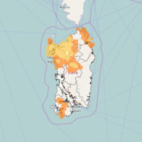
Sardegna
The coloured circles represent the total number of activities (project, products and services, outreach, collaborations) that we have in the corresponding geographical zone
Map data: © OpenStreetMap contributors
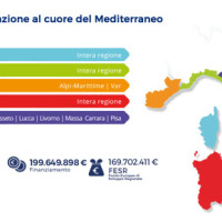
Progetto ADAPT
 The ADAPT project, co-funded by the Interreg Italy-France Maritime Program 2014-2020, aims to adapt the Italian and French cities of the Upper Tyrrhenian to the consequences of climate change, with particular reference to the urban flash floods caused by intense meteorological ...
 Agreement with the Autonomous Region of Sardinia
 In Italy, landslides are triggered by intense and/or prolonged rainfall. The spatial and temporal forecast of multiple landslides triggered by rainfall in wide areas relies primarily on empirical rainfall thresholds. It is widely believed that the thresholds are influenced by the local topographic (morphological), lithological, soil, and climatic settings. For this reason, it is necessary to define local rainfall thresholds. Reliable local ...
 Lo studio del CNR sugli ultimi 60 anni. In Sardegna le inondazioni fanno più vittime che nel resto d’Italia
 Articolo a firma Cristiana Pulcinelli pubblicato ne L'Unità del 20 novembre 2013 contenente l'intervista a Paola ...
 Cnr: sulla Sardegna alta mortalità per inondazioni
Articolo pubblicato nel sito de La Nuova Sardegna il 19 novembre ... Geothermal Atlas of Southern Italy Project
 The Geothermal Atlas project is aimed at the characterization, classification and mapping of geothermal resources, conventional and unconventional types, for the production of electricity in the regions of Southern Italy. It also provides training and information stretched to increase the skills of the industry and the public's knowledge about the various aspects of geothermal energy, especially the unconventional, in order to promote the ...