We published a book entitled “Eventi alluvionali in Calabria nel periodo 1990-1999” (Alluvial events in Calabria from 1990 to 1999)
Link to the Book»
The volume is the result of a study that lasted more than a year, and was part of long-lasting research effort to investigate historical landslide and flood events in Calabria, which started in the ‘70s of last century.
To search the information, we went to the Public Provincial ...
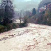
Flash floods occur in small to medium size river basins, and are characterised by fast temporal evolution. Because of their intensity and short warning times, flash floods often cause not only major economic damage, but also loss of lives.
An integrated approach to documentation and analysis of flash floods has to include the following issues:
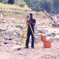
post-flood observations aimed at estimating peak discharge and reconstructing temporal ...
The project is focused on flood forecasting and hydraulic risk, i.e. the assessment of the effects of flooding in flood-prone areas also involving the vulnerability assessment of the hydraulic structures (dams, leaves, bridges, etc.).
The effects of flood events are not completely eliminated by structural measures, therefore it is necessary to develop complementary non-structural measures, such as real-time Flood Forecasting and Warning ...

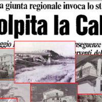
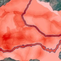
ARCO is the historical archive concerning the geo-hydrological events that occurred in Calabria (south Italy) between 1850 and 1990. The archive is made of 506 folders. 45 folders contain projects of land reclamation, management works of fluvial basins and refunding requests carried out after earthquakes. 461 folders, sorted per municipality, contain refunding requests due to geo-hydrological events, communications between citizens and public ...
The project aims at using Soil Moisture Active and Passive (SMAP) soil moisture (SM) products at different spatial resolution (3, 9, and 36 km) for hydrological applications in Europe (mainly in ...
The service analyzes the climate change impact on the main hydro-meteorological variables involved in the hydrological cycle and, in particular, on extreme events of rainfall and discharge (droughts and floods). The service allows to evaluate the combined effects of natural and human processes related to climate change on surface runoff and groundwater, analyzing the possible consequences of such effects on the strategic water ...
Hydraulic hazard maps for return periods of 50, 100, 200 and 500 ...
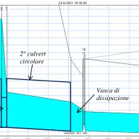
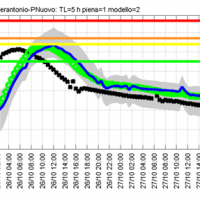
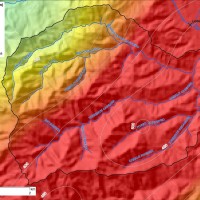
Semi-distributed continuous hydrological model (MISDc) for real-time soil moisture estimate and river discharge prediction in the Upper-Middle Tiber River basin; flood wave routing model (STAFOM-RCM) for stage hydrograph forecasting at some selected hydrometric stations in the Tiber River basin; Rainfall-runoff database coupled with the kinematic model KS for an expeditious estimate of probability flooding ...
The project activities were carried out in two phases:
"dynamic scenarios of flood risk" identification through hydrologic-hydraulic modeling addressed to Civil Protection activities (2009-2011);
operational implementation of developed dynamic scenarios of flood risk and results dissemination trough web-GIS technologies, also within the context of Floods Directive 2007/60 /EC (2012-203); flood forecasting models implementation; ...
The project activities were carried out in two phases:
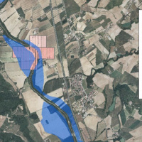
delineation of flooding-prone areas for many river reaches selected in the secondary hydrographic network of Tiber River basin (2009-2011);
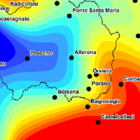
analysis of the severe flood event that affected the Paglia river basin on November ...
The artificial reservoirs are fundamental for water resources management, by regulating releases to meet the different users request (industrial, irrigation, hydropower, etc.), and for downstream territories floods defence through lamination of critical flood waves.
The main objective of the project concerns the review of hydrological-hydraulic studies carried out for the Montedoglio dam, on Tiber River, Casanuova dam, on Chiascio River, ...
The project activities concern:
development and implementation of: 1) a semi-distributed continuous hydrological model (MISDc) for real-time soil moisture estimate and river discharge prediction in the Upper-Middle Tiber River basin; 2) a flood wave routing model (STAFOM-RCM) for stage hydrograph forecasting at some selected hydrometric stations in the Tiber River basin;
support for installation of soil moisture sensors in the ...
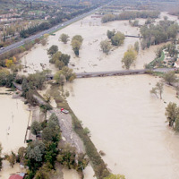
On 25-27 November 2005, the territory of central Italy was affected by heavy rainfall that hit the Tiber River basin and, mainly, the province of Perugia. The meteoric event had a significant phase with a duration of approximately 48 hours with widespread precipitation up to a maximum accumulated value higher than 100 mm. Significant increases in water levels occurred in most rivers of Upper-Middle Tiber
causing extended flooding in ...

The proposal intends to contribute towards the establishment of a long-term partnership between the EUMETSAT Satellite Application Facility on support to Operational Hydrology and Water Management (H-SAF, or Hydrology SAF) and the NASA/JAXA Global Precipitation Measurement (GPM) ...
Nel 2014 ricorrono vent’anni dalla tragica alluvione che nel novembre 1994 colpì gran parte del territorio piemontese, con perdita di vite umane, di beni mobili ed immobili. L’alluvione 1994 costituì altresì un momento storico nel campo della pianificazione territoriale, prevenzione e gestione della pericolosità e rischio geologico-idraulico, che si tradusse in dettami normativi, per l’epoca avanzati e lungimiranti. Da quell’evento ...
FLIRE is a demonstration project aiming to the development of an integrated Decision Support System (DSS) for both flash floods and forest fires risk assessment and management. The DSS tool will be designed by using state of art tools, technologies and methods and taking into account prevention, adaptation and interaction issues. The final model will be online available to key stakeholders and relevant authorities (local and national) for the ...
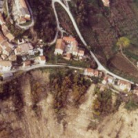
The occurrence of flash floods in mountainous catchments is often associated to relevant geomorphic effects, both in the channel network (channel changes and transport of large wood), and on the hillslopes (landslides and soil erosion). The concomitance of flash floods, channel changes and landslides enhances hazards and risk associated to individual ...
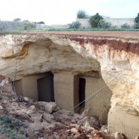
The high fragility of karst terrains, and the deriving vulnerability to a number of possible events, together with the presence of significant natural (first and foremost, groundwater), landscape and historical resources, are at the origin of the project activities, aimed at the safeguard of karst environments and the mitigation of the related ...
Flash-floods develop at space and time scales that conventional observation systems for rainfall and river discharge are not able to monitor. Consequently, the atmospheric and hydrological generating mechanisms of flash-floods are poorly understood, leading to highly uncertain forecasts of these ...
Hydrometeorological monitoring and flood forecasting are indispensable in preventing hydraulic hazard and ensuring civil protection. Implementing a sustainable plan to combat floods requires further activities, such as best practices for agricultural, forestry and land use management in flood risk areas. Methodologies must be developped within a transnational context, transending local ...
