In recent decades, InSAR data has been extremely helpful in identifying and delineating active landslides, as well as enhancing our understanding of geo-hydrological instability. However, due to the complexity and limitations of interpreting InSAR data, there is a need for guidelines to facilitate its operational use in detecting slow landslide ...
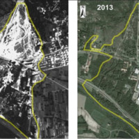
The IRPI Aerialphotografical archive consists of about 170000 aerial photographs of Northern Italy (1954-2005) useful for a stereoscopic vision. It also includes military flights (Royal Air Force) carried out during the Second World War. For some areas there are also rare aerial shots of the years 20, 30 and 40, often in diachronic form (5-10 years). The documentation refers to geo-hydrological events occurring on large areas and characterized ...
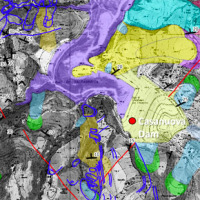
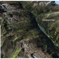
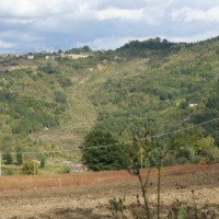
The reservoir of Casanuova on the Chiascio river, Central Umbria, occupies an area affected by numerous landslides, already identified in the regional cartographies. However, the potential interaction between the evolution of landslides and the reservoir is not evaluable because the available landslide inventories are not updated and do not contain information on the morphological evolution over time of the slopes that drain into the reservoir. ...
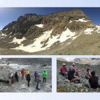
The researches at high-elevation sites continues, thanks to the RiST2 project (co-financed by Fondazione CRT of Torino). The study area is the Bessanese glacial basin. The Alpine environment and in particular the cryosphere, is responding quickly and with great intensity to climate change. The air temperature increase observed in the Alps urge the scientific communities involved in natural instability studies to consider not only air ...
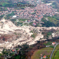
The Maierato landslide (Vibo Valentia Province) is a complex movement, which involved a significant thickness of geomaterials (rocks and soils) and rapidly flowed away for one kilometre. Owing that, the surrounding zone is interested by the same geological settings that predisposed the Maierato landslide, it is useful to identify any elements indicative of the presence of instabilities that can be triggered and evolved as the Maierato ...
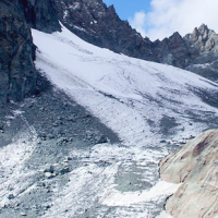
The Alpine environment, and in particular the high-altitude one, is responding quickly and with great intensity to climate change, through evidences of geomorphological, hydrological and ecological type. Mountain glacier shrinkage and related outcropping of rock walls and debris, changes of the precipitation and temperature patterns, are some of the main terrestrial indicators of climatic ...
Usually the video cameras installed within a debris-flow monitoring site have the role of recording videos to better understand the behavior of the event for an improved interpretation of its dynamic. The use of such cameras for Image Velocimetry purpose is still nowadays a ...
The company "Progetto Gestione Bacino Bari Cinque srl" has entrusted at the Research Institute for Geo-Hydrological Protection of the CNR the “Hydrogeological study for the risk analysis of the site where the plant of the treatment and disposal of solid urban waste of the same company is located in Contrada Martucci, municipality of Conversano ...
The territory of Ginosa was severely affected by flood and instability problems in October and in December 2013, as many other municipalities at the boundary between Apulia and Basilicata. In particular, on October 7, 2013, four fatalities and serious damage had to be registered. Following these events, other instabilities have occurred, including the collapse of a stretch of Via Matrice, above artificial cavities, on January 21, ...
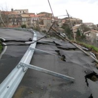
The instabilities that affected the historical part of Mesagne (Brindisi province, Apulia) since January 21, 2014, induced the local Authority to issue evacuation decrees for 18 families, corresponding to a total of 26 people. CNR IRPI was asked to provide scientific support for the identification of the processes at the origin of the ...
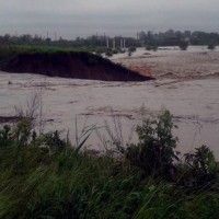
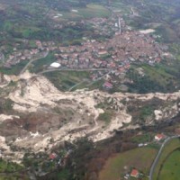
On December 3, 2013, a large landslide activated on the SW slope of Montescaglioso (Matera province, Basilicata), affecting an area with evidence of past instability. The landslide involved some 500 m of the main road to the village, and also interested several houses and other ...
The Fantiano quarries at Grottaglie (Taranto province) are an ancient sector of extraction of the local calcarenite rock, that is now used for concerts and shows. The instability phenomena observed in the quarries forced the Municipality of Grottaglie to ask to CNR-IRPI to perform stability analyses in the ...
Castelfranci (Avellino, Campania) is located in the catchment of the Calore River, in correspondence of a N-S oriented stretch of the river. This territory is intensely affected by landslide development, which more than once was in the past at the origin of severe damage to the local community, and heavy losses to ...
In the last decades Europe and Italy suffered many damaging floods, causing thousands of deaths, the displacement of millions of people and billions of euros in insured economic losses. Veneto Region has been also strongly stricken in 2010. The European Commission has identified the need for adaptation of risk management in several documents in order to reduce the likelihood and/or the impact of floods [1]. Starting from these remarks, the main ...
The occurrence of flash floods in mountainous catchments is often associated to relevant geomorphic effects, both in the channel network (channel changes and transport of large wood), and on the hillslopes (landslides and soil erosion). The concomitance of flash floods, channel changes and landslides enhances hazards and risk associated to individual ...
The entrance of the tunnel "San Lorenzo" in Forni di Sotto (UD) has built over a an active landslide body. The gravitational deformations of the slope are damaging the lining of the tunnel and creating a hazardous ...
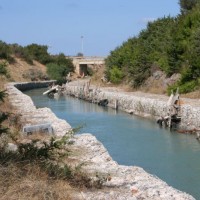
Sinkholes are in Apulia among the main geohazards, and are at the origin of severe interactions with the anthropogenic environment, and heavy losses to society. Since several years the territory of Marina di Lesina is diffusely affected by development of sinkholes (that have caused an emergency state to be declared), mostly concentrated near the Acquarotta Channel, linking the Lesina Lake to the Adriatic ...
Among the most recent sinkhole events, registered in Apulia region, that occurred in Via Firenze at Gallipoli on March 29, 2007, greatly raised the attention by public opinion, having affected (likely, without causing any fatalities) the built-up areas of one of the largest towns in Salento. The event pointed out to the need to carry out detailed studies on the sinkholes related to artificial ...
In the winter of 2009-2010, after the previous winter 2008-2009 when widespread hydrogeological instabilities had affected the whole of Calabria, the same area was still hardly hit by numerous and heavier instability phenomena, punctual and areal. In the context outlined it was ordered by the Italian Government to draft a "Plan excerpt for urgent action" which covered, in particular, the main city of the region, Catanzaro (Ianò district), and ...

One of the main challenges in the field of engineering geology is the comprehension of the triggering mechanisms of landslides and the forecast of possible evolutionary scenarios in order to assess the correct mitigation measures. Landslides can be initiated by a variety of triggers: from earthquakes to meteorological events, including intense or prolonged rainfall, rapid snow melting, and variations of the surface temperature conditions. ...
With reference to landslides, Italy is exposed to high-risk conditions (Guzzetti, 2000). The abundant and prolonged rains fallen in the 2008-2009 and 2009-2010 wet seasons triggered numerous landslides in Calabria, mostly in its northernmost sector. Such geo-hydrological crises were severe enough to induce the Italian government to declare the State of Emergency on both ...
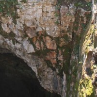
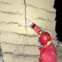
Evolution of cave and karst system occurs also by means of successive detachments of blocks from both the vault and the walls of the underground spaces. In show caves, this poses problems for the safety of visitors, and the issue must be carefully ...
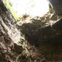
Evolution of cave and karst system occurs also by means of successive detachments of blocks from both the vault and the walls of the underground spaces. In show caves, this poses problems for the safety of visitors, and the issue must be carefully ...
