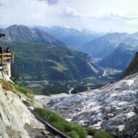
Climate changes affecting the planet need to pay great attention to evaluate the related effects, primarily in mountain territories, first sentinels of climate change. The actively involvement of high-altitude refuges, a precious asset for weather and climate surveillance of the Italian mountains, need to increase and improve knowledges about climate change effects on these infrastructures, requiring specific assessment and investigation ...
The research activity aims at defining a coherent and unambiguous framework for the assessment and zonation of seismically induced landslides, at different geographical, temporal and management scales. To this end, the project works at the pre-event temporal scale, concerning spatial planning and soil protection and corresponding to years to decades time periods, and at the real-time or civil protection scale, corresponding to time periods ...
Il progetto intende formulare una metodologia innovativa, basata su un approccio multi-disciplinare, per una valutazione appropriata della suscettibilità al collasso di cavità artificiali in aree urbane del territorio italiano, considerando le peculiarità geologiche e geo-meccaniche degli ambienti ipogei, nonché le loro interazioni con gli elementi vulnerabili dell’ambiente urbanizzato. In particolare, si intende predisporre una ...
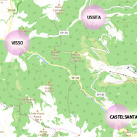
The seismic events that have affected central Italy since 24 August 2016 have caused extensive damage in the municipalities of Castelsantagelo sul Nera, Ussita and Visso (Marche Region). In order to proceed with the reconstruction, it is necessary to carry out interventions to reduce the hydraulic risk in urban ...
ITALGAS requires a certification attesting the conformity of the backfill material used for its distribution ...

The project SAPERE is an Industrial Research oriented project (PON and FAR funds) focused on promoting the competitiveness of the National Aerospace Technology Cluster. The participants to the project include 8 private firms of the Cluster (industrial component), with Thales Alenia Space Italia being the leader, as well as academic (University) and research (CNR-National Research Council) ...
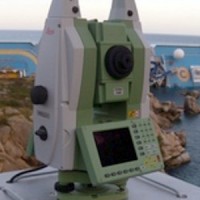
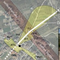
Following the run aground off near the "Isola del Giglio" (Tuscany, Italy, January 13, 2012) of the cruise vessel "Costa Concordia", a monitoring system for handling the security of the SAR (Search and Rescue) operations and for the control of the ships' movements/deformations during the subsequent defueling and recovery phases has been progressively installed and ...
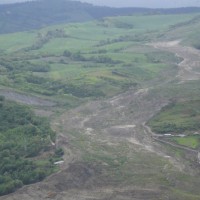
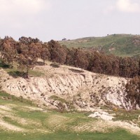
In the spring of 2006, a large failure started moving in the Montaguto municipality, Campania, southern Italy, 40 km ENE of Benevento and 35 km SW of Foggia. The movement was a partial reactivation of an older mass movement in the same general area. In April 2010, the earthflow reached the Cervaro River valley, advancing at a maximum rate of approximately 5 ...
The L’Aquila earthquake occurred the 6th April 2009, causing several casualties and damages to a large number of buildings and infrastructures. The event was a 6.3 moment magnitude (Mw). In the days following the earthquake, several aftershocks with Mw>4 affected the same general area. In total, within an area of about 50 km radius from L’Aquila town, the seismic sequence counted ca. 2×10⁴ events in about one year. Among the severely ...
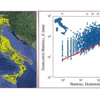
In Italy, slope failures occur every year, claiming lives, causing economic disruption, and producing different environmental problems. In Italy, intense or prolonged rainfall is the primary trigger of landslides. Predicting rainfall-induced slope failures is a challenging task of both scientific and societal interest. The forecast of single or multiple landslides triggered by rainfall in wide areas relies primarily on empirical rainfall ...
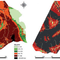
Calabria is part of the 27% of the Italian territory deemed at desertification risk from the Plan of the National Area with Puglia, Sicilia and Sardegna. This project had a realization in an area called Valle dell’Esaro, close to Crotone, that is an area with high desertification risk. In fact, this area for its soil, climate, morphology characteristics and for the agricultural procedures represents the best site to test a model of good ...
The Calabria region, because of its climatic, geomorphological and anthropic characteristics, is one of the regions most exposed to the risk of desertification in the Mediterranean basin. Methods already known in the literature and new approaches were applied at a basin scale on an area of the Ionian side, that, for rainfall and climatic characteristics, is one of the most exposed to this ...
