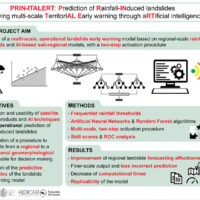
Predicting the occurrence of rainfall-induced landslides is a crucial task for civil protection purposes. Several landslide early warning systems are currently operating worldwide at different spatial scales. In Italy, landslide alerts are issued for territorial units named Alert Zones, covering a few thousand km². Usually, regional-scale warning models rely on rainfall thresholds, which require a few parameters and provide clear results in ...

Geodiversity refers to the variety of natural abiotic features, as the natural variety of geological (rocks, minerals), geomorphological (landforms, physical processes), hydrological and soil properties. The parameter “geomorphodiversity” is a measure of the dynamics of the Earth's surface and it has a key role in conservation of biodiversity and sustainability of ecosystems. Thus, it affects evolution of the biotic world and of human life. ...

Italy is an extremely fragile territory, widely exposed to hydrogeological hazards affecting anthropic infrastructures and the natural environment. In this scenario, geomorphological maps, including the representation of the spatial distribution of landforms, have been used for a long time for the description of processes acting on the Earth’s surface. Geomorphological maps should represent the basic tool for the assessment of ...

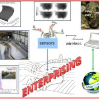
The development of an innovative system for monitoring river flows during extreme events and the impact of hydrodynamic pressures on ecosystems are two important challenges identified by the World Meteorological Organization for flood event control and by the European Commission for the European Biodiversity Strategy for the protection of ecosystems and ...

In Italy a significant increase of landslide frequency and intensity in the last decades has been occurred, whose impact must be evaluated with respect to the convergence in possible negative effects of both rainfall regime changes and of urban development as well as land use changes. Italy, due to its geomorphological and urbanization characters, represents today large areas where landslide risk is at the highest ...

Puglia is one of the italian region with a higher density of hypogean sites of great value from the archaeological historical and artistic point of view. Many of them are in so precarious conditions that it is not possible to comprehend the precise history of the places and to define restoration interventions for their utilization and ...

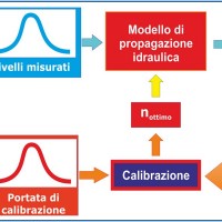
River discharge monitoring is fundamental for the study of the hydraulic regime of river flow and for the validation and calibration of rainfall-runoff models. The assessment of channel roughness coefficients associated with the measured discharges is fundamental for the calibration of flood routing models that can be used to address civil protection activities in real time. Unfortunately, the number of river flow monitoring stations in the ...
 Geodiversity refers to the variety of natural abiotic features, as the natural variety of geological (rocks, minerals), geomorphological (landforms, physical processes), hydrological and soil properties. The parameter “geomorphodiversity” is a measure of the dynamics of the Earth's surface and it has a key role in conservation of biodiversity and sustainability of ecosystems. Thus, it affects evolution of the biotic world and of human life. ...
  Italy is an extremely fragile territory, widely exposed to hydrogeological hazards affecting anthropic infrastructures and the natural environment. In this scenario, geomorphological maps, including the representation of the spatial distribution of landforms, have been used for a long time for the description of processes acting on the Earth’s surface. Geomorphological maps should represent the basic tool for the assessment of ...
  The development of an innovative system for monitoring river flows during extreme events and the impact of hydrodynamic pressures on ecosystems are two important challenges identified by the World Meteorological Organization for flood event control and by the European Commission for the European Biodiversity Strategy for the protection of ecosystems and ...
  Puglia is one of the italian region with a higher density of hypogean sites of great value from the archaeological historical and artistic point of view. Many of them are in so precarious conditions that it is not possible to comprehend the precise history of the places and to define restoration interventions for their utilization and ...
  River discharge monitoring is fundamental for the study of the hydraulic regime of river flow and for the validation and calibration of rainfall-runoff models. The assessment of channel roughness coefficients associated with the measured discharges is fundamental for the calibration of flood routing models that can be used to address civil protection activities in real time. Unfortunately, the number of river flow monitoring stations in the ...


