
Switzerland
The coloured circles represent the total number of activities (project, products and services, outreach, collaborations) that we have in the corresponding geographical zone
Map data: © OpenStreetMap contributors
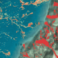
Where we should not expect landslides?
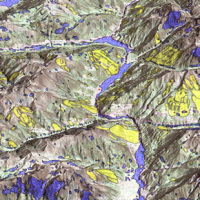 Landslide susceptibility is the propensity of a territory to generate landslides.
Many methods are available to determine landslide susceptibility, whereas only a few attempts were made to outline areas not likely to generate landslides i.e., non-susceptible landslide areas. This is surprising, because for planning purposes it is just as important (if not more important) to know where landslides are not expected than to know where landslides ...
Landslide susceptibility is the propensity of a territory to generate landslides.
Many methods are available to determine landslide susceptibility, whereas only a few attempts were made to outline areas not likely to generate landslides i.e., non-susceptible landslide areas. This is surprising, because for planning purposes it is just as important (if not more important) to know where landslides are not expected than to know where landslides ... ALMOND-F, an ALarm and MONitoring system for Debris-Flows
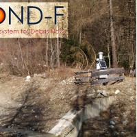 ALMOND-F is an innovative unit for the microseismic detection of debris flows using a network of geophones.
The microseismic detection of debris flows is more complex than other types of monitoring. Use of the geophones requires: (1) the selection of the level of amplification of the signal, which depends on the distance from the stream; (2) the selection of the sampling frequency of the seismic signal, which must be sufficiently high; (3) ...
ALMOND-F is an innovative unit for the microseismic detection of debris flows using a network of geophones.
The microseismic detection of debris flows is more complex than other types of monitoring. Use of the geophones requires: (1) the selection of the level of amplification of the signal, which depends on the distance from the stream; (2) the selection of the sampling frequency of the seismic signal, which must be sufficiently high; (3) ... Towards geohazards resilient infrastructure under changing climates
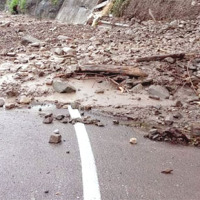 A trend of increasingly frequent intense rainfalls and changing rainfall patterns is causing a relevant number of landslides and floods affecting urban areas and engineering infrastructures such as roads, railways. Recently Transport networks across Europe experienced several failures the reasons of which are still poorly understood.. To improve the current situation, a step change in the way we design reliable and effective defence structures ...
 Installation AIS in the Breithorn area (Switzerland)
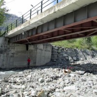
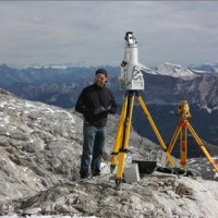
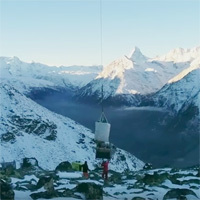 Following the European project Lampre and according between CNR-IRPI and Swiss Federal Office of the Environment, the GeoHazard Monitoring Group (GMG) have installed an Automated Inclinometer System in the BreitHorn area (Kanton Wallis) at 2900 m altitude. The monitoring system, patented by CNR-IRPI allows realizing automatically high-precision inclinometer measurements to evaluate deep-seated ground deformations. More informations at the ...
 Randa landslide
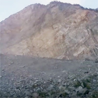 During installation of an Automatic Inclinometer System in the Breithorn landslide area - Kanton Wallis (Switzerland) - 21/10/2015 - was also carried out a fast aerial observation on the Randa landslide located a few kilometers from the Breithorn.
By Paolo Allasia and Franco Godone from CNR ...
During installation of an Automatic Inclinometer System in the Breithorn landslide area - Kanton Wallis (Switzerland) - 21/10/2015 - was also carried out a fast aerial observation on the Randa landslide located a few kilometers from the Breithorn.
By Paolo Allasia and Franco Godone from CNR ... Connecting European Connectivity Research
 Water and sediment connectivity has emerged in recent years as a significant conceptual framework for understanding the transfer of surface water and sediment through landscapes. Connectivity can be seen both as a driver of hydrological and geomorphic processes within a catchment and as an emergent catchment property that is the result of processes acting at different ...
 Landslide Modelling and tools for vulnerability assessment Preparedness and REcovery management
 Il progetto FP7 LAMPRE - Landslide Modelling and tools for vulnerability assessment Preparedness and Recovery management svolge attività di ricerca innovative e di sviluppo tecnologico per migliorare le capacità del sistema Copernicus di far fronte a eventi di frana e alle loro conseguenze, in Europa e in altre parti del mondo. LAMPRE migliora il rischio di frana sforzi di mitigazione / preparazione e le attività di recupero e di ...
 Alarm and monitoring systems for debris and mud flows
 Monitoring of debris flows in instrumented areas is carried out since many years in different Countries worldwide. It is still missing, however, an adequate standardization of methodologies, instrumentations and procedures. The instrumented areas are also employed for testing warning systems. Even though these latter have been more and more employed, a systematic experimentation of these systems has not yet been carried ...
 Long-term Permafrost Monitoring Network
 Permafrost is very sensitive to climate change and the risks associated with its degradation affect traffic routes, settlements and infrastructure. Data on the distribution of permafrost are inconsistent and there is no common strategy to tackle this problem. Local administrators should have the means to manage the risks associated with the degradation of the ...
 Mountain Risks: from prediction to management and governance
 The observed increase in disastrous events over the last decades, associated with a low perception of risk by the communities involved, along with the lack of efficient, socially accepted and environmentally sound remedial measures are amongst the motivation behind this research project. The adaptation of a combined multi-risk-oriented analysis, in which the investigations focus more on the interdependence of events rather than on single event, ...