
Romania
The coloured circles represent the total number of activities (project, products and services, outreach, collaborations) that we have in the corresponding geographical zone
Map data: © OpenStreetMap contributors
Where we should not expect landslides?
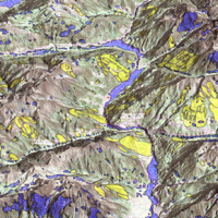 Landslide susceptibility is the propensity of a territory to generate landslides.
Many methods are available to determine landslide susceptibility, whereas only a few attempts were made to outline areas not likely to generate landslides i.e., non-susceptible landslide areas. This is surprising, because for planning purposes it is just as important (if not more important) to know where landslides are not expected than to know where landslides ...
Landslide susceptibility is the propensity of a territory to generate landslides.
Many methods are available to determine landslide susceptibility, whereas only a few attempts were made to outline areas not likely to generate landslides i.e., non-susceptible landslide areas. This is surprising, because for planning purposes it is just as important (if not more important) to know where landslides are not expected than to know where landslides ... Landslide susceptibility models and maps
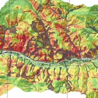
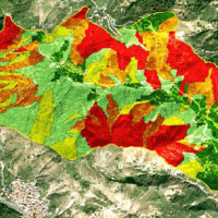 Landslide susceptibility is the likelihood of a landslide occurring in an area, given the local terrain conditions. It is the degree to which an area can be affected by future landslides i.e., an estimate of “where” landslides are more likely to occur.
Landslide susceptibility does not consider the temporal occurrence or the magnitude of the expected landslides. In mathematical language, landslide susceptibility can be expressed as the ...
Landslide susceptibility is the likelihood of a landslide occurring in an area, given the local terrain conditions. It is the degree to which an area can be affected by future landslides i.e., an estimate of “where” landslides are more likely to occur.
Landslide susceptibility does not consider the temporal occurrence or the magnitude of the expected landslides. In mathematical language, landslide susceptibility can be expressed as the ... Connecting European Connectivity Research
 Water and sediment connectivity has emerged in recent years as a significant conceptual framework for understanding the transfer of surface water and sediment through landscapes. Connectivity can be seen both as a driver of hydrological and geomorphic processes within a catchment and as an emergent catchment property that is the result of processes acting at different ...
 Increasing Resilience through Earth Observation
 To significantly contribute to the operational capacities in the context of Global Monitoring for Environment and Security (GMES)/ Copernicus by developing customised mapping and geo-information products addressing risk, vulnerability and assets ready for deployment in the prevention and preparedness phases – complementary to the GMES/Copernicus Emergency Management Service. Solutions to be provided are based for the most part on Earth ...
 Changing Hydro-meteorological Risks as Analyzed by a New Generation of European Scientists
 The European Commission has identified the need for adaptations in risk management as a consequence to climate and environmental changes in several documents. The implementation of risk management measures such as disaster preparedness programmes, land-use planning, regulatory zoning and early warning systems are considered essential. Further, multi-risk assessment approaches are not used in planning practice: risk indicators are hardly used ...
 Hydrometeorological data resources and technologies for effective flash flood forecasting
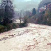 Flash-floods develop at space and time scales that conventional observation systems for rainfall and river discharge are not able to monitor. Consequently, the atmospheric and hydrological generating mechanisms of flash-floods are poorly understood, leading to highly uncertain forecasts of these ...
 Monitoring, Forecasting and Best Practices for FLOOD Mitigation & Prevention in the CADSES Region
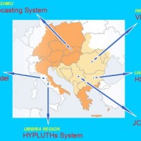 Hydrometeorological monitoring and flood forecasting are indispensable in preventing hydraulic hazard and ensuring civil protection. Implementing a sustainable plan to combat floods requires further activities, such as best practices for agricultural, forestry and land use management in flood risk areas. Methodologies must be developped within a transnational context, transending local ...