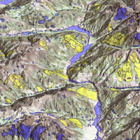
Landslide susceptibility is the propensity of a territory to generate landslides.
Many methods are available to determine landslide susceptibility, whereas only a few attempts were made to outline areas not likely to generate landslides i.e., non-susceptible landslide areas. This is surprising, because for planning purposes it is just as important (if not more important) to know where landslides are not expected than to know where landslides ...

The research activity aims at defining a coherent and unambiguous framework for the assessment and zonation of seismically induced landslides, at different geographical, temporal and management scales. To this end, the project works at the pre-event temporal scale, concerning spatial planning and soil protection and corresponding to years to decades time periods, and at the real-time or civil protection scale, corresponding to time periods ...
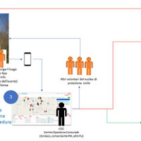
The management of emergencies, in particular those determined by natural events, is complex and must be able to use all the available cognitive elements. During emergencies, it is possible to acquire useful data regarding the processes that determine the same emergencies. These data can contribute to significantly improve planning and design of prevention ...
The urbanisation of seismically active areas, coupled with the ongoing change in climate patterns, require a shift in the approaches to land/infrastructure instability hazard assessment and risk reduction. This is particularly relevant in seismically active regions where the recurrent damage from landsliding, subsidence and ground deformations can be widespread. Geotechnical investigations and in situ monitoring of land prone to instability are ...
The project is focused on monitoring geohazard-associated ground deformations, a key prevention action specifically addressed to urban areas and critical infrastructures. The project will propose a procedure to produce maps to assess continuously the potential impact of geohazard activity. These maps will provide inputs to support early warning, giving information on the stability of the monitored areas and to evaluate the expected ...
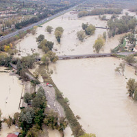
The project is focused on flood forecasting and hydraulic risk, i.e. the assessment of the effects of flooding in flood-prone areas also involving the vulnerability assessment of the hydraulic structures (dams, leaves, bridges, etc.).
The effects of flood events are not completely eliminated by structural measures, therefore it is necessary to develop complementary non-structural measures, such as real-time Flood Forecasting and Warning ...

The 3DA software is a new procedure that allows retrieving in near-real-time 3D surface deformation models starting from data acquired via robotized total stations or others system that acquire the surface displacements. The measurements are first pre-processed and then implemented on 3D maps that include vector arrows representative of the intensities and of the real directions of motion in a given system of coordinates. The 3D surface ...
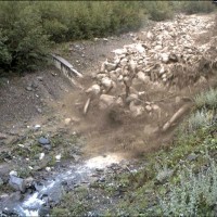
The understanding of the changing equilibrium between sediment supply from upstream and sediment transport capability of a river is important for the success of integrated water resource management. In Alpine river basins, intensive sediment transport processes and sediment continuity have a notable impact on several water management issues posing multiple use conflicts related to hydropower, ecology, flood control ...
The entrance of the tunnel "San Lorenzo" in Forni di Sotto (UD) has built over a an active landslide body. The gravitational deformations of the slope are damaging the lining of the tunnel and creating a hazardous ...
Permafrost is very sensitive to climate change and the risks associated with its degradation affect traffic routes, settlements and infrastructure. Data on the distribution of permafrost are inconsistent and there is no common strategy to tackle this problem. Local administrators should have the means to manage the risks associated with the degradation of the ...
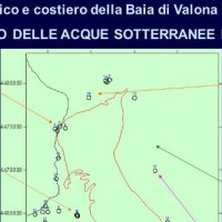
The project CISM faces problems related to marine Albanian waters in view of the Adriatic basin, which must meet various environmental problems in other portions of the Adriatic Sea, which are still influenced by the contribution of Albanian waters. CISM is not only a time of growth of the scientific culture of Albania, but also a landmark in the international scenario of the Adriatic ...
