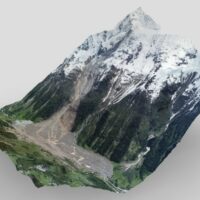
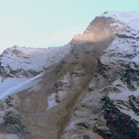
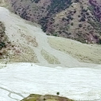
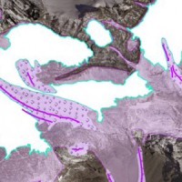
On 28 May 2025, at15:24 (CEST), the frontal part of the Birch Glacier in Valais (CH), estimated at around 3 million m3, collapsed, dragging with it over 6 million m3 of debris that had accumulated on its surface over the previous weeks, following a sequence of rockfalls from the northern slope of the Kleines Nesthorn (3335 m a.s.l.). The ice mass disintegrated immediately after detachment, giving rise to a catastrophic ice-rock avalanche with a ...
Geological-geotechnical monitoring systems are one of the most effective tools for landslide characterization, both in terms of landslide detection and for monitoring purposes. The regional monitoring network of Regione Lombardia represents an exemplary case in Italy, with as many as 44 landslides monitored, of which more than half in real time.
The management of monitoring networks and early warning systems represents a complex component, in ...
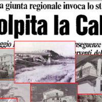
We published a book entitled “Eventi alluvionali in Calabria nel periodo 1990-1999” (Alluvial events in Calabria from 1990 to 1999)
Link to the Book»
The volume is the result of a study that lasted more than a year, and was part of long-lasting research effort to investigate historical landslide and flood events in Calabria, which started in the ‘70s of last century.
To search the information, we went to the Public Provincial ...
Landslide susceptibility is the propensity of a territory to generate landslides.
Many methods are available to determine landslide susceptibility, whereas only a few attempts were made to outline areas not likely to generate landslides i.e., non-susceptible landslide areas. This is surprising, because for planning purposes it is just as important (if not more important) to know where landslides are not expected than to know where landslides ...

Despite the large number and frequency of landslides and floods that affect our territories, and the information on landslides and floods available also online, the subject of geo-hydrological hazards remains poorly known to the Italian citizens. The lack of understanding reflects in the limited perception of the population on the geo-hydrological risks in Italy.
One reason for the lack of understanding is the way in which the subject of ...
A recent research has been carried out by Marco Pagani, researcher of the Institute of Cognitive sciences and technologies of the Italian National Research Council (Istc-Cnr) in Rome. The research has documented, with electroencephalographic monitoring techniques (EEG), the cerebral effects deriving from the re-processing of a traumatic memory (https://www.cnr.it/it/news/5761/dall-emdr-un-aiuto-per-superare-i-traumi). In particular, the ...
Il progetto intende formulare una metodologia innovativa, basata su un approccio multi-disciplinare, per una valutazione appropriata della suscettibilità al collasso di cavità artificiali in aree urbane del territorio italiano, considerando le peculiarità geologiche e geo-meccaniche degli ambienti ipogei, nonché le loro interazioni con gli elementi vulnerabili dell’ambiente urbanizzato. In particolare, si intende predisporre una ...
The MUHA project is building upon the idea to address disaster management cycle consisting of preparedness-response-mitigation-rebuild components in the ADRION countries. It will connect the observed and modelled hazards and risks related to the integrated water cycle, by effectively join them with the existing and improved coping capacity developed by national, bilateral and EU Civil Protection ...
In recent years, following short and intense meteoric events, along the railway line of the Department of Reggio Calabria, there have been a series of interruptions in correspondence of basins below 3-4 km2. Based on the current procedures for risk mitigation in RFI, in the event of a "red alert" issued by the Civil Protection, RFI management locate along the railway line personal in correspondence of the area in question. This procedure is ...
Coastal areas are particularly sensitive to climate change. Because these areas have become particularly susceptible to extreme physical phenomena because of a significant increase in human pressure, climate change will cause heightened exposure and vulnerability of the population. The Authorities ought to make strong efforts to: i) take the necessary measures and actions to reduce the negative impacts of the natural phenomena on the coastal ...
Climate change in the Greater Alpine Region is seriously affecting glacial and periglacial areas, especially for the presence of snow, glaciers and permafrost (cryosphere), with relevant consequences on slope stability. Cryosphere degradation, changes of the precipitation and temperature patterns and of the hydrological regimes, are some of the main terrestrial indicators of climatic change. Moreover, the increasing number of tourists and human ...
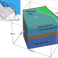
The topic of low geothermal enthalpy is crucial as a strategy to mitigate and adapt to climate change.
With this in mind, the structuring of environmental knowledge and information on the topic of low geothermal enthalpy in its various forms and a test site activity to deepen current knowledge on the regulatory context and on the effects on subsoil and on groundwater of geothermal plants is envisaged on a territorial ...
The project concerns the mitigation of natural hazards (mainly the effects on the territory and the anthropic environment caused by rains, earthquakes, volcanism, and Radon gas). The geological characterization is essential to frame the contexts and the expected phenomena. Numerical modeling and monitoring allow to predict the spatio-temporal evolution of the phenomena, and therefore to evaluate the risk for mitigation ...
The project is focused on monitoring geohazard-associated ground deformations, a key prevention action specifically addressed to urban areas and critical infrastructures. The project will propose a procedure to produce maps to assess continuously the potential impact of geohazard activity. These maps will provide inputs to support early warning, giving information on the stability of the monitored areas and to evaluate the expected ...
The improved understanding of the underlying physical processes of extreme events is closely linked to the development and verification of procedures to better control, analysis and validation of hydrological data for the description and visualization of meteorological events creating an operational "database of event" which enables to better identify under what conditions hazards ...
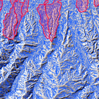
L’area del "Passo della Morte" (UD) è interessata da una situazione di grave dissesto a causa della presenza di più movimenti franosi. Questi sono caratterizzati da elevata pericolosità in relazione alle caratteristiche intrinseche dei fenomeni (volumetrie e velocità di spostamento), alla morfologia del versante ed alla geologia dell'area. La loro presenza mette a rischio la rete stradale che collega la Carnia con il Cadore e l’asta ...
The research topics involve the consideration of geological, geomorphological, hydrological, hydrogeological, and technology and the use of innovative methodologies to achieve the sustainability of the natural balance inherent inland waters, with a focus on groundwater and river water. Finally, we consider the effects of climate change on the hydrological cycle and anthropogenic modifications to emphasize the contribution of these modifications ...
Both China and Italy are characterized by large mountainous areas, where natural hazards (e.g., geological and hydrological hazards such as debris flows, landsides, flash floods) are widespread and seriously threatening local society. It is noted that, almost 67% and 76% of the territories are covered by mountains in China and Italy, respectively and the youngest chains in the Eurasia, namely the Alps and the Tibetan Plateau, are characterized ...
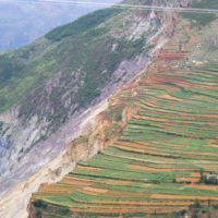
In international literature, it is now widely recognized that alluvial fans are areas of high geomorphic activity. Debris flows and flash floods occur episodically in these environments, and place many communities at high risk. Calabria (southern Italy) is a region where alluvial fans widely occur. In this region, the presence of mountain fronts/alluvial and/or coastal plain, or deep and narrow valleys debouching into larger valleys are key ...

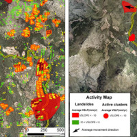
The 3DA software is a new procedure that allows retrieving in near-real-time 3D surface deformation models starting from data acquired via robotized total stations or others system that acquire the surface displacements. The measurements are first pre-processed and then implemented on 3D maps that include vector arrows representative of the intensities and of the real directions of motion in a given system of coordinates. The 3D surface ...
SAFETY aims at providing Civil Protection Authorities with the capability of periodically evaluating and assessing the potential impact of geohazards (volcanic activity, landslides and subsidence) on urban areas. The project improves the effort to detect and map geohazards, assess their activity and evaluate their impact on built-up areas and infrastructures ...
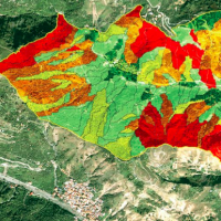
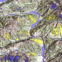
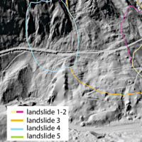
A landslide susceptibility map forecasts where landslides are expected to occur in the future based on terrain conditions, including local morphological, geological, and land use settings. Using different colors, a landslide susceptibility map shows forecasted levels of landslide susceptibility in a region. Using specific software, LSMMs can be prepared whene new landslides or new environmental (e.g., morphological, geological, land use) data ...
Climate change in the Greater Alpine Region is seriously affecting glacial and periglacial areas, with relevant consequences on slope stability. Cryosphere degradation, changes of the precipitation and temperature patterns and of the hydrological regimes, are some of the main terrestrial indicators of climatic change. Moreover, the increasing number of tourists and human activities rise the level of ...
The European Commission has identified the need for adaptations in risk management as a consequence to climate and environmental changes in several documents. The implementation of risk management measures such as disaster preparedness programmes, land-use planning, regulatory zoning and early warning systems are considered essential. Further, multi-risk assessment approaches are not used in planning practice: risk indicators are hardly used ...
The project is included in Operative Program of the European cross-border territorial cooperation "Alcotra 2007-2013". It brings together specialized scientific expertise Italian and French that deal to study the mountain and its dangerousness. It is divided into a part of studies conducted on the entire framework of the Western Alps and in actions on the pilot sites identified by the ...
PREVIEW is an integrated project by the European Commission 6th Framework Programme, led by the EURORISK Consortium, a multi-disciplinary European Team of committing Actors of the domain: Civil Protections and Environmental Bodies; Scientific communities and Service operators, at national and regional level, for Meteorology, Hydrology, Seismology, Volcanology and GIS services based on Space data; and Industry. The project was organized around a ...
