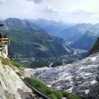
Climate changes affecting the planet need to pay great attention to evaluate the related effects, primarily in mountain territories, first sentinels of climate change. The actively involvement of high-altitude refuges, a precious asset for weather and climate surveillance of the Italian mountains, need to increase and improve knowledges about climate change effects on these infrastructures, requiring specific assessment and investigation ...
A Geo-hydrological event (EDId) (landslides, mass movements, floods, etc.) can result in a high social and economic impact, especially if it is generated by multiple simultaneous phenomena, when it is able to produce social hardships and economic damage characterized by important and lasting effects. The identification of the typical elements of the phenomena that can contribute to an EDId (typify) is essential to adequately define the risk ...
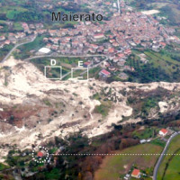
The Maierato landslide (Vibo Valentia Province) is a complex movement, which involved a significant thickness of geomaterials (rocks and soils) and rapidly flowed away for one kilometre. Owing that, the surrounding zone is interested by the same geological settings that predisposed the Maierato landslide, it is useful to identify any elements indicative of the presence of instabilities that can be triggered and evolved as the Maierato ...
The knowledge of the geo-hydrological hazard of a territory and of the risk conditions for people, are essential for the implementation of civil protection activities. The monitoring activity by personnel, voluntary or not, is a strategic resource for all phases of civil ...
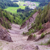
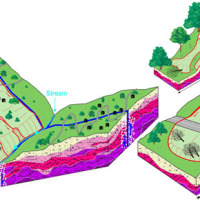
Past debris flows in the Rio Kortol catchment arise concerns for the safety of the village of Sauris di Sotto, and urge new studies for the assessment of hazard and the choice of risk mitigation ...
The project concerns the mitigation of natural hazards (mainly the effects on the territory and the anthropic environment caused by rains, earthquakes, volcanism, and Radon gas). The geological characterization is essential to frame the contexts and the expected phenomena. Numerical modeling and monitoring allow to predict the spatio-temporal evolution of the phenomena, and therefore to evaluate the risk for mitigation ...
The study of the dynamics of large landslide is a heuristic process based on the integration of multiple investigation techniques: geological and geomorphological analysis, monitoring systems (traditional and innovative) and numerical models. Risk mitigation may require major interventions that call for detailed studies on the specific ...
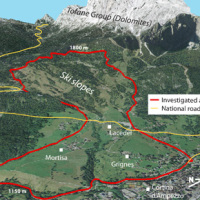
The project aims at defining the type of expected natural hazards, the modeling approaches relevant for their evaluation, and possible monitoring tools in specific areas prone to landslide risk within the "UNESCO site Portovenere, Cinque Terre and the Islands (Palmaria, Tino and Tinetto)" along the "Blue Trail" from Monterosso through ...
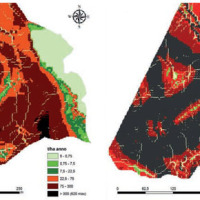
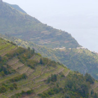
Calabria is part of the 27% of the Italian territory deemed at desertification risk from the Plan of the National Area with Puglia, Sicilia and Sardegna. This project had a realization in an area called Valle dell’Esaro, close to Crotone, that is an area with high desertification risk. In fact, this area for its soil, climate, morphology characteristics and for the agricultural procedures represents the best site to test a model of good ...

The 3DA software is a new procedure that allows retrieving in near-real-time 3D surface deformation models starting from data acquired via robotized total stations or others system that acquire the surface displacements. The measurements are first pre-processed and then implemented on 3D maps that include vector arrows representative of the intensities and of the real directions of motion in a given system of coordinates. The 3D surface ...
Large part of the territory is affected by geomorphological instability, often threatening the anthropic environment. Technical and socio-economic reasons often impose coexistence with the risks. Therefore, appropriate risk mitigation and/or reduction strategies must be implemented. Field and laboratory investigations, monitoring, modelling techniques and cartographic analyses are essential tools to acquire the necessary ...
Economic analysis has produced a set of analysis on natural disasters to measure the impacts of the events, the possibility of insurance schemes, and the optimization of prevention policies. In Italy these economic analysis are not widespread and the information on damage is limited. The available estimates are limited to the public money spent for post-event reconstruction and do not correspond to the total social ...
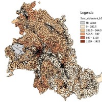
The Strategic Project PS_119 was aimed at developing a methodology for the landslide risk assessment, applicable at the regional scale and based on the most advanced knowledge in the fields of geology, geotechnics, structural engineering and urban planning. This assessment was based on a deterministic approach of the landslide processes and the risks related to them. The failure slope mechanisms, the structural damages due to landsliding and ...
