Landslide susceptibility is the propensity of a territory to generate landslides.
Many methods are available to determine landslide susceptibility, whereas only a few attempts were made to outline areas not likely to generate landslides i.e., non-susceptible landslide areas. This is surprising, because for planning purposes it is just as important (if not more important) to know where landslides are not expected than to know where landslides ...
Water is at the centre of economic and social development; it is vital to maintain health, grow food, manage the environment, and create jobs. As well over half of the world’s potable water supply is extracted from rivers, either directly or from reservoirs, understanding the variability of the stored water on and below landmasses, i.e., total runoff, is of primary importance. In situ observations or land surface/hydrological models are ...

The 3DA software is a new procedure that allows retrieving in near-real-time 3D surface deformation models starting from data acquired via robotized total stations or others system that acquire the surface displacements. The measurements are first pre-processed and then implemented on 3D maps that include vector arrows representative of the intensities and of the real directions of motion in a given system of coordinates. The 3D surface ...
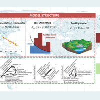
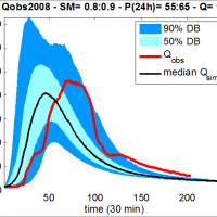
The service is based on a procedure consisting of four main steps: the analysis of hydro-meteorological data for the reconstruction of flood event in terms of precipitations and saturation conditions of the soils; assessment of the hydrological response of the basin; runoff estimation in each hydrometric site of interest; flooded areas delineation and comparison with in-situ ...
Hydraulic hazard maps for return periods of 50, 100, 200 and 500 ...
The project activities were carried out in two phases:
"dynamic scenarios of flood risk" identification through hydrologic-hydraulic modeling addressed to Civil Protection activities (2009-2011);
operational implementation of developed dynamic scenarios of flood risk and results dissemination trough web-GIS technologies, also within the context of Floods Directive 2007/60 /EC (2012-203); flood forecasting models implementation; ...
The project activities were carried out in two phases:
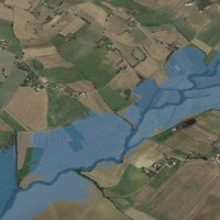
delineation of flooding-prone areas for many river reaches selected in the secondary hydrographic network of Tiber River basin (2009-2011);
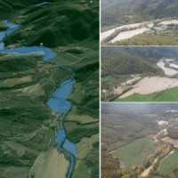
analysis of the severe flood event that affected the Paglia river basin on November ...
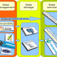
We provide maps and layers through standard OGC services and WebGIS applications.
Our aim is to disseminate information on landslides and floods hazards and the related risk.
More specifically the services focus on thematic data concerning landslides and floods, including: (i) landslide inventory maps at different scales and covering different geographical areas, (ii) landslide susceptibility, hazard and risk maps, and (iii) information on ...
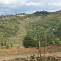
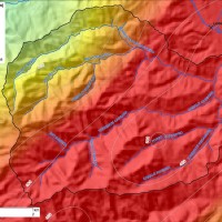
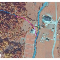
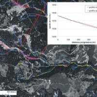
Castelfranci (Avellino, Campania) is located in the catchment of the Calore River, in correspondence of a N-S oriented stretch of the river. This territory is intensely affected by landslide development, which more than once was in the past at the origin of severe damage to the local community, and heavy losses to ...
The occurrence of flash floods in mountainous catchments is often associated to relevant geomorphic effects, both in the channel network (channel changes and transport of large wood), and on the hillslopes (landslides and soil erosion). The concomitance of flash floods, channel changes and landslides enhances hazards and risk associated to individual ...
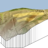
The application of distributed physically based models is possible on relatively small areas, typically hundreds or few thousands of km2. Distributed modelling of slope dynamics requires many sufficiently detailed information. Knowledge of geotechnical parameters and land use, digital terrain models, medium/high resolution cartography, temporal evolution of soil moisture conditions, are ...
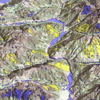
Realizzazione di modelli e carte di suscettibilità da frana tipo scorrimento per il territorio della Regione ...
Existing geomorphological maps on the Apulian territory show some inconsistencies, that might have effects as concerns the limits of restriction areas for the location of works. To have available an updated and scientifically sound product, TRE Spa asked CNR IRPI a scientific consultancy for the production of geomorphological ...
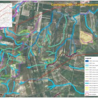
The accurate representation of the channel network is fundamental in cartography. The increasing availability of high-resolution, LiDAR-derived DTMs provides an excellent topographic basis for the representation of the channel network, but requires innovative techniques for managing and processing ...
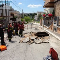
The widespread sinkholes that involve large sectors of the Apulian territory are related to natural cavities produced by karst processes in soluble rocks, or to man-made cavities deriving from different types of human activities in different historical ages. The related hazard is extremely high, with very severe damage to built-up areas and human infrastructures, and heavy losses to the ...
The widespread occurrence of sinkholes related to man-made cavities in Apulia highlights the need to perform a careful reconnaissance of the artificial caves over the whole region, and of their stability conditions. Knowledge of the presence and typology of artificial cavity, and of its main features, is a mandatory step for the mitigation of the sinkhole ...
The assessment debris-flow hazard is of utmost importance in the management of alpine catchments. The analysis of morphometric variables of drainage basins and channels can contribute to preliminary assessment of debris-flow hazard at regional ...
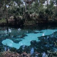
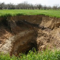
Sinkholes are among the main features of karst areas, and are extremely widespread in Florida, one of the sites most known for their occurrence and the likely interaction with the built-up environment. The Tampa area, in turn, shows an high frequency of events, which origin derives from different types of ...
Debris flows and rockfalls are a familiar hazard in European mountain areas and regularly cause loss of life, livelihood and property. Hazard assessment is therefore increasingly required in land use planning. However, there are no standard techniques and existing operational techniques are qualitative.
DAMOCLES developed quantitative technologies for assessing the distribution of rapid slope failures and their hazard, for determining the ...
