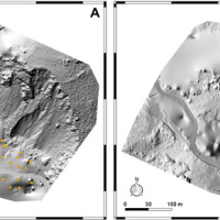
The use of remotely piloted aircraft systems (RPASs) in geosciences is often aimed at the acquisition of an image sequence to produce digital models and orthophotographs of the topographic surface. Such photogrammetric technique can be applied for rockfall hazard and risk assessment. To study rockfalls, an approach consists in the application of numerical models for the computation of rockfall trajectories. Data required for such simulations ...
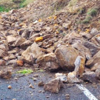
Among all types of landslide phenomena present in Alpine environment, the rockfalls are certainly the most impacting, because they also are extremely widespread. Rockfall are very difficult to monitor and they are often managed exclusively through the execution of active or passive works aimed at risk mitigation. Due to the rockfalls impulsive behavior, it is a difficult task to locate them a priori. The problem of rockfalls can be approached ...
Making reports of rockfall in the area affected by the earthquake in central Italy in ...
The permafrost degradation is a probable cause of the increase of rock instabilities and rock falls observed in recent years in high mountain areas. It causes the thaw of the ice filling rock discontinuities producing water that subsequently freezes again, inducing stresses that lead to rock falls. Rock-falls are among the most hazardous instability processes in high mountain environments because of their velocity and the difficulty to ...
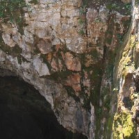
Evolution of cave and karst system occurs also by means of successive detachments of blocks from both the vault and the walls of the underground spaces. In show caves, this poses problems for the safety of visitors, and the issue must be carefully ...
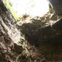
Evolution of cave and karst system occurs also by means of successive detachments of blocks from both the vault and the walls of the underground spaces. In show caves, this poses problems for the safety of visitors, and the issue must be carefully ...
