
SMOS+RAINFALL II
Exploiting multi-mission satellite soil moisture retrievals for rainfall correction through SM2RAIN and SPATIAL algorithms (SMOS+RAINFALL II)
Background
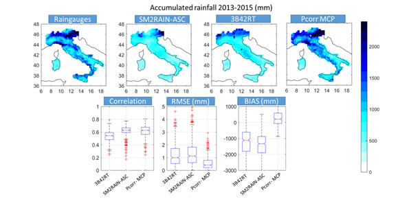
Quantitative information about precipitation is one vital input to meteorologists, hydrologic scientists, water resources managers, and environmental legislators. The past SMOS+Rainfall project addressed the improvement on a global scale of the current state-of-the-art satellite rainfall products through satellite soil moisture observations derived from the Soil Moisture and Ocean Salinity mission (SMOS) by means of three different techniques. The three methodologies demonstrated the potential of satellite soil moisture in improving satellite derived rainfall in various climatologic conditions. However, the low temporal resolution of SMOS and its accuracy and availability (caused by Radio Interferences) did not guarantee the success of the correction in all conditions.
Purpose
The main objective of the project is to assess the potential of a multimission versus only one satellite correction approach to enhance rainfall information over land and test the resulting product in flood forecasting and crop modelling applications.
Methods
Two approaches are used in the project: the fusion of SM2RAIN based rainfall products obtained from different satellite soil moisture products and the relative state-of-the art rainfall product through a Bayesian (MCP) and an Optimal Linear Interpolator (OLI) techniques and The Soil Precipitation AssimilaTIon ALgorithm (SPATIAL) algorithm, which is based on the application of a particle filter assimilation method in a simple soil moisture-precipitation model based (i.e., the Antecedent Precipitation Index API mode)l.
Products
- Long-term enhanced rainfall dataset derived from the integration of state-of-the-art rainfall observations and satellite soil moisture-based rainfall.
- Procedure for the correction of the rainfall in near real time.
 Internal contact person: christian massari -