Joint modeling of landslides and erosion processes
LANDscape Plants LANdslide and Erosion – LANDPLANER is an open source software for the joint modelling of landslides and erosion processes triggered by rainfall. LANDPLANER is designed to describe the dynamic response of slopes or catchments, and their susceptibility to instability phenomena under different changing scenarios, including meteorological, vegetation, land-use, and morphological changes.
Different approaches have been proposed to model landslide and erosion processes separately. Only a few attempts have been made to model landslide and erosion jointly. Some models consider the effects of landslides on sediment yield and transport. In other cases, landslides and erosion processes are components of a landscape evolution model. However, existing models do not describe jointly the triggering mechanisms of landslide and erosion processes, and their competing effects on the slopes. Landslide triggering depends primarily on the distribution of rainfall. Erosion processes are related to surface runoff, and landslides to infiltration.
Rainfall intensity, slope morphology, vegetation and soil characteristics play an important role in determining the water repartition on the soil surface, and control the triggering of landslides and erosion processes. LANDPLANER (LANDscape, Plants, LANdslide and ERosion) was designed and implemented to satisfy these requirements.
LANDPLANER is a distributed, raster-based model able to estimate the effects of rainfall on the triggering of landslides and erosion processes. The model, written in R, is open source and uses standard spatial input and output data formats.
LANDPLANER consists of three modeling components:
An hydrological model, for water repartition (rainfall [P], runoff [Q], infiltration [I], exfiltration [Ex], evapotranspiration [EPT] as the sum of soil evaporation [Ev] and plant transpiration [T]);
An erosion model, to predict where erosion processes can occur;
A slope stability model, to predict where landslide phenomena can occur.
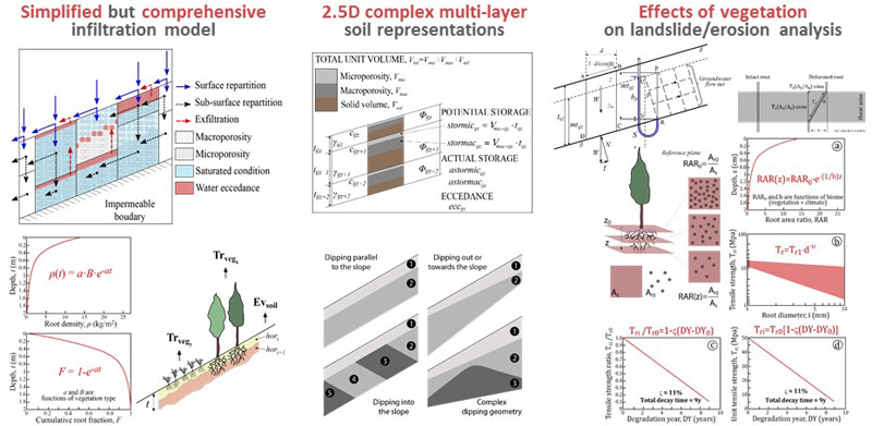
LANDPLANER integrates the role of slope morphometry (terrain elevation and slope, contributing area, drainage direction), vegetation (runoff propensity derived by Curve Number, root effects on plant transpiration and soil cohesion), and soil hydrological/geotechnical properties.
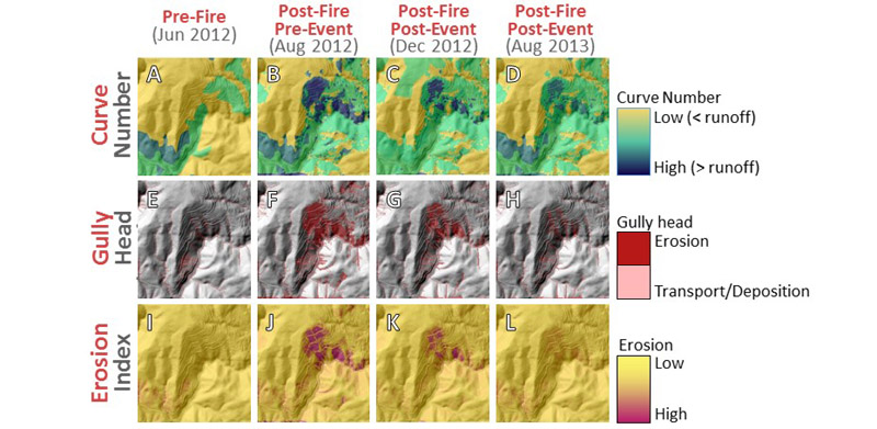
The hydrological model integrates a rainfall/runoff component, and an infiltration component, providing inputs for the analysis of erosion and landslide processes. The rainfall-runoff model is based of the Curve Number (Natural Resources Conservation Service, United States Department of Agriculture, NRCS USDA) method, allowing for the estimation of runoff starting from information on land use and soil conditions.
LANPLANER implements a simplified infiltration model. Water on the surface can infiltrates and is stored in the microporosity and the macroporosity of the soil layers. Water can move to the lower layers or downslope along the layer boundaries. Even if simplified, the model can consider different layer geometries and boundary conditions (permeable or impermeable).
The erosion-modeling schema is twofold, and it integrates:
A topographic threshold, dependent on slope morphology and soil/vegetation/land use characteristics, and
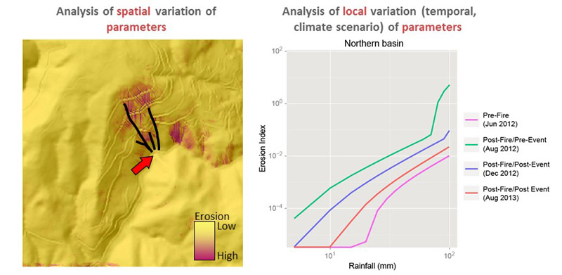
An erosion index, calculated from the results of the hydrological model.
The slope instability model is a classical infinite slope, limit equilibrium method (LEM), and it considers the effects of cohesion produced by roots in the soil.
Rossi M, Torri D, Santi E. 2015. Bias in topographic thresholds for gully heads. Natural Hazards, 1-19. DOI: 10.1007/s11069-015-1701-2.
Rossi M, Torri D, Santi E, Bacaro G, Marchesini I, Mondini A, Felicioni G. 2014. Slope Dynamics and Climatic Change Through Indirect Interactions. Engineering Geology for Society and Territory 1, 551-555, Springer International Publishing. DOI 10.1007/978-3-319-09300-0_103.
Rossi M. Modeling of landslide phenomena and erosion processes triggered by meteo-climatic factors. PhD Thesis, University of Perugia, October 2014. Advisors: Fausto Guzzetti, Dino Torri, Daniela Valigi. DOI: 10.13140/2.1.3835.0404.
Home » Focus » Joint modeling of landslides and erosion processes