A landslide is the movement of a mass of rock, debris or earth along a slope under the influence of gravity.
Landslides pose serious threats in many areas of the world, and knowing their location, distribution and classification is important for land use planning. Landslide identification and mapping is a fundamental activity for an effective defence from the damage caused by landslides to the population and to structures and the ...
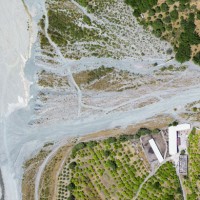
Alluvial fans are known to be areas of high geomorphic activity, where debris flows and flash floods caused by intense and prolonged rainfall are a major hazard. In Calabria, southern Italy, alluvial fans are numerous. The exact age of the alluvial fans is seldom known, but most of the fans in Calabria are considered recent in age (Holocene).
Due to the significant increase in urbanization in the last two centuries, many alluvial fans are ...
Landslide susceptibility is the propensity of a territory to generate landslides.
Many methods are available to determine landslide susceptibility, whereas only a few attempts were made to outline areas not likely to generate landslides i.e., non-susceptible landslide areas. This is surprising, because for planning purposes it is just as important (if not more important) to know where landslides are not expected than to know where landslides ...
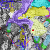
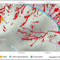
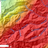
The reservoir of Casanuova on the Chiascio river, Central Umbria, occupies an area affected by numerous landslides, already identified in the regional cartographies. However, the potential interaction between the evolution of landslides and the reservoir is not evaluable because the available landslide inventories are not updated and do not contain information on the morphological evolution over time of the slopes that drain into the reservoir. ...
The STRESS project is intended to design, implement and test a prototype of a Spatial Information Infrastructure (SII) enabling the provision to spatial planners and risk managers of new data and tools to improve hydro-geological susceptibility, hazard and impact assessment as well as to experiment alternative decision making ...
Making reports of rockfall in the area affected by the earthquake in central Italy in ...
An Event Landslide Inventory Map (ELIM) shows the location and extent of landslides caused by a specific natural trigger, such as an intense rainfall event, a period of prolonged rainfall, a rapid snowmelt event, or an earthquake. The methods and tools developed by CNR-IRPI allow preparation of an ELIM anywhere recent landslides have left discernible ...
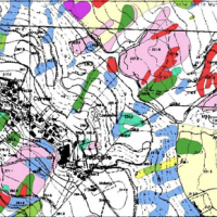
A Landslide Inventory Map (LIM) shows the location, spatial extent and type of landslides in a ...
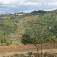
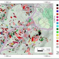
Castelfranci (Avellino, Campania) is located in the catchment of the Calore River, in correspondence of a N-S oriented stretch of the river. This territory is intensely affected by landslide development, which more than once was in the past at the origin of severe damage to the local community, and heavy losses to ...
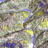
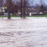
The occurrence of flash floods in mountainous catchments is often associated to relevant geomorphic effects, both in the channel network (channel changes and transport of large wood), and on the hillslopes (landslides and soil erosion). The concomitance of flash floods, channel changes and landslides enhances hazards and risk associated to individual ...
