La missione Copernicus Sentinel-3 Surface Topography fornisce informazioni estremamente preziose sulla quota della superficie delle acque continentali e dei ghiacci marini e terrestri, grazie al suo altimetro SAR che misura l’altezza ad alta risoluzione lungo la sua traccia e la sua orbita coprendo anche le regioni polari ad alta latitudine.
Per garantire che queste misure possano essere utilizzate con fiducia e per massimizzare il ritorno ...
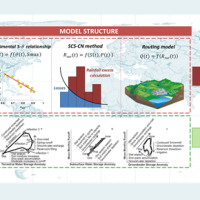
L'acqua è al centro dello sviluppo economico e sociale; è fondamentale per la salute, coltivare il cibo, gestire l'ambiente e creare posti di lavoro. Poiché oltre la metà dell'approvvigionamento mondiale di acqua potabile viene estratta dai fiumi, direttamente o da serbatoi, è di primaria importanza comprendere la variabilità dell'acqua immagazzinata sopra e sotto le masse terrestri, cioè il deflusso totale. Le osservazioni in situ o i ...
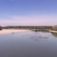
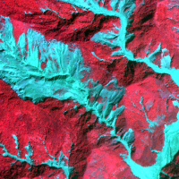
Sebbene rappresenti meno dell'1% della quantità totale di acqua sulla Terra, l'acqua dolce è essenziale per la vita terrestre e per i bisogni umani. Nonostante le esistenti reti di misura a terra rappresentino un valido strumento per quantificare il volume istantaneo di acqua in molti canali fluviali, la conoscenza delle dinamiche spaziali e temporali della portata superficiale è ancora scarsa e incompleta. Si rende necessario pertanto ...
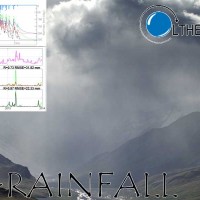
La stima della precipitazione è vitale nel campo della meteorologia, idrologia and gestione delle risorse idriche. Il progetto concluso SMOS+RAINFALL ha avuto come scopo principale quello di un miglioramento delle stime di precipitazione da satellite mediante l’uso di osservazioni satellitari di umidità del suolo derivate dalla missione Soil Moisture and Ocean Salinity mission (SMOS) utilizzando tre diverse tecniche. Le tre tecniche hanno ...
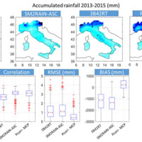
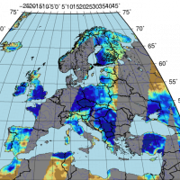
Accurate rainfall estimates are of paramount importance as rainfall plays a key-role in many fields as, to cite a few, natural hazard assessment (floods and landslides), drought management, weather forecasting, agriculture and diseases prevention. State-of-the-art rainfall products obtained by satellites are often the only way for measuring rainfall in remote areas of the ...
Irrigation is one of the greatest human intervention in the hydrological cycle. The knowledge of the distribution, the extent of irrigated areas and the amount of water used by irrigation is needed for different purposes: 1) modelling irrigation water requirements at the global scale, 2) assessing irrigated food production, 3) quantifying the impact of irrigation on climate, river discharge and groundwater depletion. Notwithstanding its ...
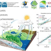
Monitoring the water cycle from satellite observations is one of the major goals of the EO community and closing the water budget has been a long-standing objective of international programs. After years of hard work, calibrating satellite data, improving inversion techniques, and facilitating the coherency of retrievals, it is admitted that the water cycle budget can now be ...
Quantitative information about precipitation is one vital input to meteorologists, hydrologic scientists, water resources managers, and environmental legislators. Yet, accurate measurement of precipitation over the relevant space and time scales remains a challenge. Soil moisture can be seen as the trace of the precipitation and, consequently, can be useful for providing a way to estimate rainfall accumulation or at least a new constrain to ...
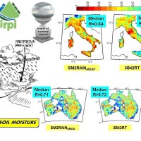
State-of-the-art satellite rainfall products are often the only way for measuring rainfall in remote areas of the world. However, these products may fail in properly reproducing the amount of precipitation reaching the ground, which is needed for hydrological applications. The integration of satellite soil moisture products is expected to significantly improve rainfall ...
Recently, IRPI-CNR has developed an innovative approach for estimating rainfall from satellite soil moisture data, named SM2RAIN. The ESA funded project “Climate Change Initiative - Soil Moisture“ (CCI-SM) offers a valuable opportunity for testing SM2RAIN algorithm to a continuous, homogenous, long-term (>30 years) soil moisture time series. Indeed, SM2RAIN has the chance to be tested not only for rainfall estimation but also as a ...
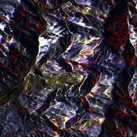
L’uso di metodologie innovative per il trattamento di dati SAR e ottici, combinato a dati ancillari, è in grado di fornire prodotti avanzati utili nell’ambito della valutazione della pericolosità da frana e pericolosità ...
The project aims at using Soil Moisture Active and Passive (SMAP) soil moisture (SM) products at different spatial resolution (3, 9, and 36 km) for hydrological applications in Europe (mainly in ...

Le missioni Sentinel di ESA forniranno nuove capacità in termini di tempo di rivisitazione e copertura. Il loro migliore utilizzo consiste nella loro combinazione per migliorare ulteriormente il tempo di rivisita e l’uso di differenti lunghezze d’onda. Questo si riflette nella capacità di identificare cambiamenti indotti da diversi fattori, inclusi disastri naturali e pratiche ...

The proposal intends to contribute towards the establishment of a long-term partnership between the EUMETSAT Satellite Application Facility on support to Operational Hydrology and Water Management (H-SAF, or Hydrology SAF) and the NASA/JAXA Global Precipitation Measurement (GPM) ...
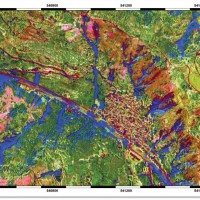
Terremoti e intense precipitazioni innescano frane ovunque. Inventari degli effetti al suolo di un evento devono essere preparati in pochi giorni per la gestione del rischio residuo. Immagini satellitari e tecniche di image-processing stanno affiancando metodi tradizionali di mappatura. Obiettivo di questo progettoè aumentare l’automazione ...
The project explores and implements multi-scale and multi-sensor SAR change detection methodologies for event landslide mapping. Automated analysis for change detection is a challenging task due
to the inherent noisiness of SAR imagery and also to the high sensitivity to texture variability due to different acquisition angles. Moreover, pre-processing (de-speckling) may lead to the degradation
of the geometrical details and affect the ...
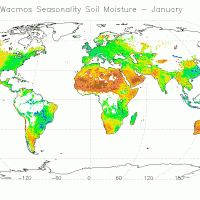
The CCI Programme wants to contribute to the data bases collecting ECVs required by GCOS (Global Climate Observing System) and other international parties. In particular, the Soil Moisture CCI will analyse the needs of the climate research community in terms of soil moisture data, adapt soil moisture satellite measurements for their use by the climate research community and create a long-term consistent soil moisture time series, based on ...
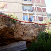
Gli sprofondamenti avvengono come collassi improvvisi del terreno, connessi a cavità naturali prodotte dal carsismo in rocce solubili, o a cavità scavate dall’uomo in epoche diverse e per scopi diversi. Sprofondamenti sono diffusi in tutto il mondo, e la relativa pericolosità è estremamente elevata, con seri danni ad aree urbanizzate e infrastrutture, e pesanti costi per la ...
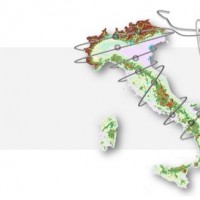
Le frane sono eventi del tutto naturali nell’evoluzione di un territorio, in particolare in Italia. Esse pongono un problema e diventano un pericolo allorché interagiscono con l’uomo e l’ambiente antropico. I movimenti franosi presentano una grande varietà fenomenologia. Le notevoli differenze nella tipologia, dimensione, e velocità di spostamento delle frane, rendono difficile e complessa la definizione della loro pericolosità, per ...
The H-SAF generates and archives high-quality data sets and products for operational hydrological applications starting from the acquisition and processing of data from Earth observation satellites in geostationary and polar orbits operated both by EUMETSAT and other satellite organization. The retrieval of products uses data from microwave and infrared instruments and aims at reaching the best possible accuracy compatible with satellite ...
