SAR change detection methodologies for event landslide mapping (GEO1749)
Progetti
Multi-scale and multi-sensor SAR change detection methodologies for event landslide mapping.
Background
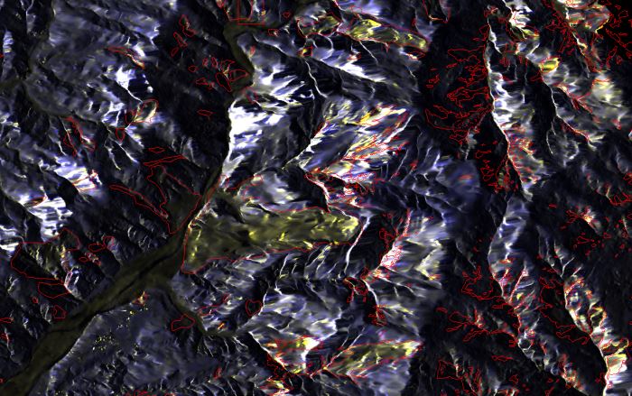
The project explores and implements multi-scale and multi-sensor SAR change detection methodologies for event landslide mapping. Automated analysis for change detection is a challenging task due to the inherent noisiness of SAR imagery and also to the high sensitivity to texture variability due to different acquisition angles. Moreover, pre-processing (de-speckling) may lead to the degradation of the geometrical details and affect the accuracy of the final change map. For this reason and also for operative issue, identify and defining a SAR change detection feature which is robust to noise and look angle variation is an open issue, especially on new high-resolution images. Particular attention is devoted to the use of the X-band SAR data in order to understand the potential and limitation of the TerraSAR-X sensor for this scope. Methodologies to derive soil moisture from SAR images under specific conditions (bare or sparsely vegetated fields) will be also eventually addressed.
Timely and accurate change detection of Earths surface features provides the foundation for better understanding relationships and interactions between human and natural phenomena to better manage and use resources. In general, change detection mappings involves the application of multi-temporal datasets to quantitatively analyze the temporal effects of the phenomenon. The use of high and very-high resolution images and the exploitation of innovative change detection techniques are important support for many application domains, such disaster mapping and risk mitigation.
All classification methods exploiting optical images and remote sensing techniques are on average successful when landslides leave distinct radiometric signatures on the terrain, like in forested terrains, in tropical and equatorial areas and in arid or sub arid environments where the vegetation cover is sparse. Clouds and haze make problematic the acquisition of satellite optical images during or just after the event resulting in a critical lack of information. SAR images promise to facilitate the measure of change detection land cover when the persistency of clouds limits the use of optical images
Scopo
The expected results of the activity are: the analysis and the assessment of TerraSAR-X X-band SAR data for the detection and mapping of landslide under different conditions, the analysis of the potential and limitations of X band SAR for the mapping and monitoring of natural processes in synergy with other RS data and auxiliary information.
Metodi
Qualitative and quantitative assessment of RS data acquired from different sensors and at different scales. Particular attention is devoted to the use of the X-band SAR data in order to understand potentials and limitations. Investigation and development of advanced, robust and customized change detection techniques and algorithms for addressing the rapid mapping of event landslides. The comparison of the products derived at different scales and from different sensors, with the aim to derive useful guidelines for their integration in the perspective of an integrated monitoring framework.