
Grecia
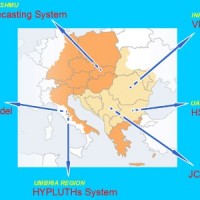
The coloured circles represent the total number of activities (project, products and services, outreach, collaborations) that we have in the corresponding geographical zone
Map data: © OpenStreetMap contributors
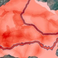
Dove non dobbiamo aspettarci frane?
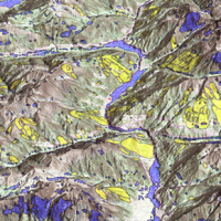 La suscettibilità da frana è la propensione di un territorio a franare.
Sono molti i metodi disponibili per determinare le aree suscettibili a franare, mentre sono pochi i tentativi di determinare le aree non suscettibili, ossia le aree dove non dobbiamo attenderci frane. Ciò è sorprendente, perché per la pianificazione territoriale è altrettanto (se non più) importante sapere dove non ci si aspettano frane che sapere dove le frane ...
La suscettibilità da frana è la propensione di un territorio a franare.
Sono molti i metodi disponibili per determinare le aree suscettibili a franare, mentre sono pochi i tentativi di determinare le aree non suscettibili, ossia le aree dove non dobbiamo attenderci frane. Ciò è sorprendente, perché per la pianificazione territoriale è altrettanto (se non più) importante sapere dove non ci si aspettano frane che sapere dove le frane ... MUltiHAzard framework for water related risks management
 The MUHA project is building upon the idea to address disaster management cycle consisting of preparedness-response-mitigation-rebuild components in the ADRION countries. It will connect the observed and modelled hazards and risks related to the integrated water cycle, by effectively join them with the existing and improved coping capacity developed by national, bilateral and EU Civil Protection ...
 STSE Water Cycle Multi-mission Observation Strategy for the Mediterranean
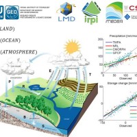 Monitoring the water cycle from satellite observations is one of the major goals of the EO community and closing the water budget has been a long-standing objective of international programs. After years of hard work, calibrating satellite data, improving inversion techniques, and facilitating the coherency of retrievals, it is admitted that the water cycle budget can now be ...
 Multi Scale and Multi Hazard MApping Space Solutions
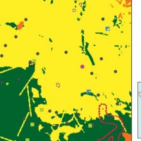
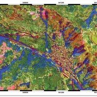 L’uso di metodologie innovative per il trattamento di dati SAR e ottici, combinato a dati ancillari, è in grado di fornire prodotti avanzati utili nell’ambito della valutazione della pericolosità da frana e pericolosità ...
 Connettere la ricerca europea sulla connettività
 La connettività idrologica e del sedimento è emersa recentemente come importante framework concettuale per indagare il trasferimento dei flussi di acqua e sedimento nei bacini idrografici. La connettività può esser vista sia come forzante dei processi idrologici e delle azioni geomorfiche all'interno del bacino, sia come una proprietà del bacino stesso che è risultato di processi che agiscono a diverse ...
 FLoods and fIre Risk assessment and managEment
 FLIRE is a demonstration project aiming to the development of an integrated Decision Support System (DSS) for both flash floods and forest fires risk assessment and management. The DSS tool will be designed by using state of art tools, technologies and methods and taking into account prevention, adaptation and interaction issues. The final model will be online available to key stakeholders and relevant authorities (local and national) for the ...
 Assessment of water Balances and Optimisation based Target setting across EU River Basins
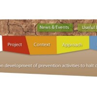 ABOT is one of the Pilot projects on Development of Prevention Activities to Halt Desertification in Europe, partly funded by DG Environment of the European Commission. The objective of the pilot projects is to support the development of concrete pilot initiatives on innovative technologies, techniques or practices in order to contribute to the exchanges of good practice and innovation for halting the desertification in ...
 Dati idrometeorologici e tecnologie per la previsione delle piene improvvise
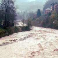 Le piene improvvise si sviluppano a scale spazio-temporali che le normali reti di misura delle precipitazione e dei deflussi nella rete fluviale non sono in grado di rilevare con efficacia. Ne consegue che i meccanismi atmosferici e idrologici che generano le piene improvvise sono spesso scarsamente conosciuti, ciò che determina rilevanti incertezze nella previsione di questi ...
 Mappe di vulnerabilità delle acque sotterranee nelle aree Archimed
 Si considera la forte domanda delle istituzioni territoriali di selezionare le migliori pratiche esistenti, in relazione alle peculiarità nazionali e locali, considerando il quadro ...
 Monitoring, Forecasting and Best Practices for FLOOD Mitigation & Prevention in the CADSES Region
 Hydrometeorological monitoring and flood forecasting are indispensable in preventing hydraulic hazard and ensuring civil protection. Implementing a sustainable plan to combat floods requires further activities, such as best practices for agricultural, forestry and land use management in flood risk areas. Methodologies must be developped within a transnational context, transending local ...
 Landslide Early Warning Integrated System
 L’interesse per le frane nasce dalla considerazione che in molti paesi europei i fenomeni di instabilità dei pendii interessano aree urbanizzate e costituiscono una minaccia significativa per la popolazione.
Attraverso l’integrazione tra dati telerilvati e dati acquisiti in sito si intende identificare le modificazioni che hanno luogo su pendii potenzialmente instabili e utilizzare tali informazioni per la valutazione del rischio da ...
L’interesse per le frane nasce dalla considerazione che in molti paesi europei i fenomeni di instabilità dei pendii interessano aree urbanizzate e costituiscono una minaccia significativa per la popolazione.
Attraverso l’integrazione tra dati telerilvati e dati acquisiti in sito si intende identificare le modificazioni che hanno luogo su pendii potenzialmente instabili e utilizzare tali informazioni per la valutazione del rischio da ... Prevention, Information and Early Warning pre-operational services to support the management of risks
 PREVIEW is an integrated project by the European Commission 6th Framework Programme, led by the EURORISK Consortium, a multi-disciplinary European Team of committing Actors of the domain: Civil Protections and Environmental Bodies; Scientific communities and Service operators, at national and regional level, for Meteorology, Hydrology, Seismology, Volcanology and GIS services based on Space data; and Industry. The project was organized around a ...