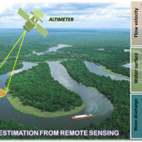
River discharge is defined as the amount of water flowing through a river over a specified period of time. Its estimate is crucial for all the operations of hydraulic structures design, the territorial planning and the flood risk assessment and management. River discharge at a specific river cross-section is not a direct measurement, but it is calculated by measuring other hydraulic quantities such as the flow velocity and the water depth, i.e. ...
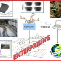
The development of an innovative system for monitoring river flows during extreme events and the impact of hydrodynamic pressures on ecosystems are two important challenges identified by the World Meteorological Organization for flood event control and by the European Commission for the European Biodiversity Strategy for the protection of ecosystems and ...
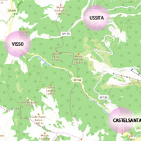
The seismic events that have affected central Italy since 24 August 2016 have caused extensive damage in the municipalities of Castelsantagelo sul Nera, Ussita and Visso (Marche Region). In order to proceed with the reconstruction, it is necessary to carry out interventions to reduce the hydraulic risk in urban ...
Il progetto prevede un’attività di servizio e di supporto tecnico scientifico per la realizzazione di progetti standard che affrontano i temi della pianificazione comunale di protezione civile e degli strumenti che possono rendere maggiore la sua efficacia. Il progetto propone uno schema che consente di definire, con metodologia rigorosa e omogenea, le attività da svolgere e il modo in cui svolgerle, per la realizzazione di un modello di ...
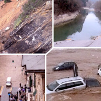
With more than 5 million people affected, more than 1000 killed, and with estimated total damages exceeding 4.5 billion Euros just in Europe and during the last decade, floods are among the most disruptive natural events threatening our Society. Due to increase in extreme weather events and rapid socio-economic developments in vulnerable locations, the risks connected to floods in general are growing rapidly, and the awareness of these risks ...
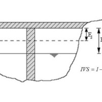
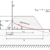
Assessment of bridge piers/abutments vulnerability to scour and overtopping hazard, assessment of levee vulnerability to seepage and overtopping hazard. The analysis is based on clearly identified criteria. Specifically, overtopping (IVS) and erosion (IVE) vulnerability indices are evaluated for each selected bridge, and the overtopping (IVsorm) and seepage vulnerability indices (IVsif) are calculated for the ...
National levees database, where the levees are identified by a code consisting in two parts: the first one identifies the river; the second one is a sequential number increasing from downstream to upstream. For each levee the location, the characteristics and topographic surveys are reported along with vulnerability to overtopping and piping, flood hazard maps and information about levee inspection and ...
