The Copernicus Sentinel-3 Surface Topography Mission (STM) provides extremely valuable surface elevation information over inland waters, sea ice and land ice, thanks to its SAR altimeter which retrieves high-resolution along-track elevation measurements, and to its orbit that covers high-latitude polar regions.
To ensure that these measurements can be used with confidence, and to maximize the return on investment of the Copernicus Sentinel-3 ...
Water is at the centre of economic and social development; it is vital to maintain health, grow food, manage the environment, and create jobs. As well over half of the world’s potable water supply is extracted from rivers, either directly or from reservoirs, understanding the variability of the stored water on and below landmasses, i.e., total runoff, is of primary importance. In situ observations or land surface/hydrological models are ...
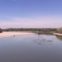
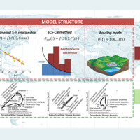
Although representing less than 1% of the total amount of water on Earth, the freshwater is essential for terrestrial life and human needs. Despite the existing in-situ gauging networks represent a tool for quantifying the instantaneous water volume in many river channels, we have surprisingly poor knowledge of the spatial and temporal dynamics of surface river discharge. Developing new procedures for river discharge estimation based on ...
Quantitative information about precipitation is one vital input to meteorologists, hydrologic scientists, water resources managers, and environmental legislators. The past SMOS+Rainfall project addressed the improvement on a global scale of the current state-of-the-art satellite rainfall products through satellite soil moisture observations derived from the Soil Moisture and Ocean Salinity mission (SMOS) by means of three different techniques. ...
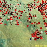
Irrigation is one of the greatest human intervention in the hydrological cycle. The knowledge of the distribution, the extent of irrigated areas and the amount of water used by irrigation is needed for different purposes: 1) modelling irrigation water requirements at the global scale, 2) assessing irrigated food production, 3) quantifying the impact of irrigation on climate, river discharge and groundwater depletion. Notwithstanding its ...
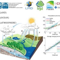
Monitoring the water cycle from satellite observations is one of the major goals of the EO community and closing the water budget has been a long-standing objective of international programs. After years of hard work, calibrating satellite data, improving inversion techniques, and facilitating the coherency of retrievals, it is admitted that the water cycle budget can now be ...
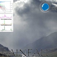
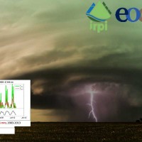
Quantitative information about precipitation is one vital input to meteorologists, hydrologic scientists, water resources managers, and environmental legislators. Yet, accurate measurement of precipitation over the relevant space and time scales remains a challenge. Soil moisture can be seen as the trace of the precipitation and, consequently, can be useful for providing a way to estimate rainfall accumulation or at least a new constrain to ...
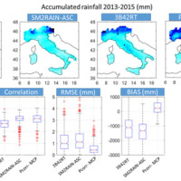
Recently, IRPI-CNR has developed an innovative approach for estimating rainfall from satellite soil moisture data, named SM2RAIN. The ESA funded project “Climate Change Initiative - Soil Moisture“ (CCI-SM) offers a valuable opportunity for testing SM2RAIN algorithm to a continuous, homogenous, long-term (>30 years) soil moisture time series. Indeed, SM2RAIN has the chance to be tested not only for rainfall estimation but also as a ...
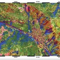
The exploitation of innovative methods of SAR and optical data processing, combined to the use of ancillary data, is able to provide useful products for the landslide and seismic hazard ...

ESA Sentinels missions will provide enhanced capabilities in the revisit frequency, and the coverage. Their complete exploitation is in the combination of the two to advantage of a further increased revisiting time and in the use of different wavelenght domains. This reflects in the capabilities to detect features of changes induced by different factors including natural hazards and crop ...
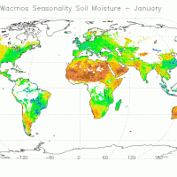
The CCI Programme wants to contribute to the data bases collecting ECVs required by GCOS (Global Climate Observing System) and other international parties. In particular, the Soil Moisture CCI will analyse the needs of the climate research community in terms of soil moisture data, adapt soil moisture satellite measurements for their use by the climate research community and create a long-term consistent soil moisture time series, based on ...
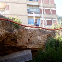
Sinkholes occur as sudden collapses of the ground, related to natural cavities produced by karst processes in soluble rocks, or to man-made cavities deriving from different types of human activities in different historical ages. Sinkholes are widespread all over the world, and the related hazard is extremely high, with very severe damage to built-up areas and human infrastructures, and heavy losses to the ...
