
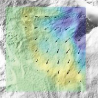
The 3DA software is a new procedure that allows retrieving in near-real-time 3D surface deformation models starting from data acquired via robotized total stations or others system that acquire the surface displacements. The measurements are first pre-processed and then implemented on 3D maps that include vector arrows representative of the intensities and of the real directions of motion in a given system of coordinates. The 3D surface ...
Real time evaluation of the rainfall and soil moisture conditions over the analysis grid point, and the combination with the available vulnerability and susceptibility information for the definition of the dynamic risk ...
Semi-distributed continuous hydrological model (MISDc) for real-time soil moisture estimate and river discharge prediction in the Upper-Middle Tiber River basin; flood wave routing model (STAFOM-RCM) for stage hydrograph forecasting at some selected hydrometric stations in the Tiber River basin; Rainfall-runoff database coupled with the kinematic model KS for an expeditious estimate of probability flooding ...
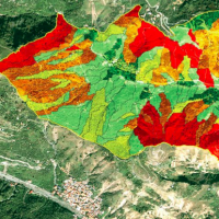
A landslide susceptibility map forecasts where landslides are expected to occur in the future based on terrain conditions, including local morphological, geological, and land use settings. Using different colors, a landslide susceptibility map shows forecasted levels of landslide susceptibility in a region. Using specific software, LSMMs can be prepared whene new landslides or new environmental (e.g., morphological, geological, land use) data ...
Based on the application of numerical modelling techniques, CNR – IRPI can provide consulting services on stability/instability conditions and kinematical evolution of potentially unstable slopes, underground caves, embankments, open-pit mines, landfills and any other type of natural or man-made soil/rock structure at ...
