Geo-Hydrological risks are one of the main sources of economic losses for our country causing a huge number of victims and damages. From 1966 to 2015, landslides and floods caused 1948 casualties, 3524 injured and more than 412,000 displaced people. The Venetian mountain has always been subject to major landslides and, almost every year, new emergencies occur with the intensification of the autumn and spring rains, which are increasing due to ...
The development of an innovative system for monitoring river flows during extreme events and the impact of hydrodynamic pressures on ecosystems are two important challenges identified by the World Meteorological Organization for flood event control and by the European Commission for the European Biodiversity Strategy for the protection of ecosystems and ...
Application of optical fibers is generally aimed at large bandwidth transmission. Few people know that the proposal of optical fibers as sensing elements is almost as old as their proposal as transmission media, and over the last two decades fibre optic sensor (FOS) technology has assumed a dominant role in several fields of application. As a matter of fact, FOSs offer many advantages with respect to legacy electronic and mechanic sensors. ...
The management of natural hazards tends radically to distribute responsibilities at the local level, as the first civil protection actors. Prevention and preparedness are long-term goals, rooted in volunteer expertise, and awareness of local citizens, using solutions of "crowd-sourced mappers". The objective is designing mobile applications, sensors and dashboard for citizens and volunteers of civil protection, with pilot study cases selected ...
This dataset consists of rainfall data and debris-flow hydrographs recorded in the Moscardo Torrent (Carnic Alps, northeastern Italy).
The Moscardo Torrent was instrumented for debris-flow monitoring by CNR IRPI (Torino office) in 1989; the research was then continued in collaboration with the Padova office. Since 2010 the monitoring activities are carried on in collaboration with the University of Udine (Dept. of Agricultural and ...

The 3DA software is a new procedure that allows retrieving in near-real-time 3D surface deformation models starting from data acquired via robotized total stations or others system that acquire the surface displacements. The measurements are first pre-processed and then implemented on 3D maps that include vector arrows representative of the intensities and of the real directions of motion in a given system of coordinates. The 3D surface ...
The project activities concern:
development and implementation of: 1) a semi-distributed continuous hydrological model (MISDc) for real-time soil moisture estimate and river discharge prediction in the Upper-Middle Tiber River basin; 2) a flood wave routing model (STAFOM-RCM) for stage hydrograph forecasting at some selected hydrometric stations in the Tiber River basin;
support for installation of soil moisture sensors in the ...
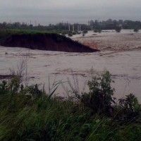
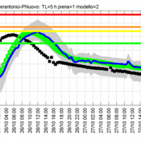
In the last decades Europe and Italy suffered many damaging floods, causing thousands of deaths, the displacement of millions of people and billions of euros in insured economic losses. Veneto Region has been also strongly stricken in 2010. The European Commission has identified the need for adaptation of risk management in several documents in order to reduce the likelihood and/or the impact of floods [1]. Starting from these remarks, the main ...
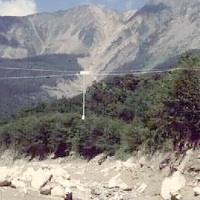
The permafrost degradation is a probable cause of the increase of rock instabilities and rock falls observed in recent years in high mountain areas. It causes the thaw of the ice filling rock discontinuities producing water that subsequently freezes again, inducing stresses that lead to rock falls. Rock-falls are among the most hazardous instability processes in high mountain environments because of their velocity and the difficulty to ...

One of the main challenges in the field of engineering geology is the comprehension of the triggering mechanisms of landslides and the forecast of possible evolutionary scenarios in order to assess the correct mitigation measures. Landslides can be initiated by a variety of triggers: from earthquakes to meteorological events, including intense or prolonged rainfall, rapid snow melting, and variations of the surface temperature conditions. ...
