Ground Deformations Risk Scenarios: an advanced assessment service
(DORIS)
Background
DORIS – Ground Deformations Risk Scenarios: an advanced assessment service is an advanced downstream service for the detection, mapping, monitoring and forecasting of ground deformations, at different temporal and spatial scales and in various physiographic and climatic and environments. DORIS integrates traditional and innovative Earth Observation (EO) and ground based (non-EO) data and technologies to improve our understanding of the complex phenomena that result in ground deformations, including landslides and land subsidence, and to foster the ability of Civil Protection Authorities to manage the risks posed by ground deformations.
DORIS delivers innovative products at the regional and local levels, tailored on the needs of national and local Civil Protection authorities. For the purpose, DORIS exploits state-of-the-art national technological and scientific capabilities. DORIS complies with guidelines provided by the EU Emergency Response Core Services (ERCS) Interdisciplinary Group, and is designed to be linked to existing Core Services, including SAFER and GMES EMERGENCY. The service benefits from the experience and the products released by the ESA GMES Pan-European Ground Motion Hazard Information Service TERRAFIRMA.
Purpose
DORIS had many objectives, including:
- Exploit & integrate satellite & ground based data, information and technologies to improve the understanding of natural & human induced phenomena that cause ground deformations, including landslides and subsidence.
- Design & implement a downstream service for detecting, mapping, monitoring and forecasting ground deformations, at different temporal & spatial scales, adopting a multi-risk approach.
- Deliver innovative and accurate information relevant to Civil Protection Authorities, providing products useful in the pre-event, the event and the post-event phases of the risk management cycle.
- Execute innovative research on the exploitation of remote sensing technology to improve the current understanding of the phenomena that cause ground deformations.
Results
DORIS has improved the state-of-the-art in the science and technology currently used to detect, map, monitor, and forecast ground deformations. Improvements consist in the innovative exploitation of EO data and technologies.
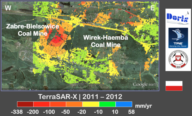
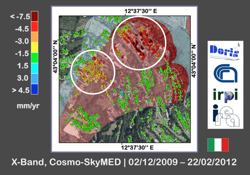
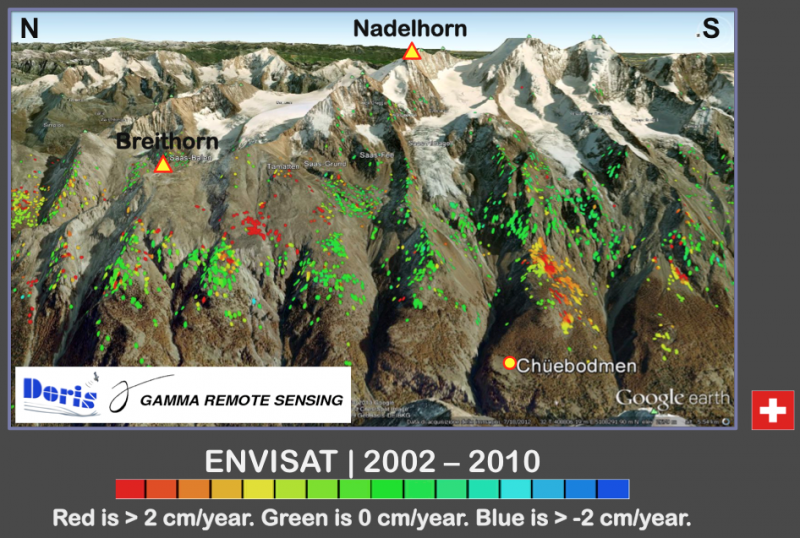
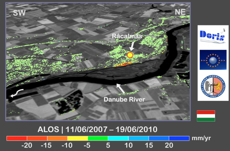
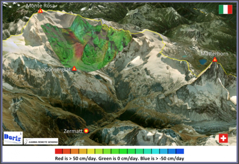
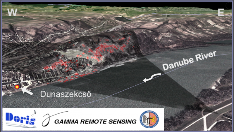
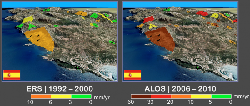
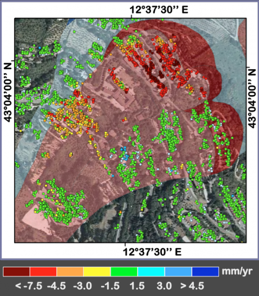
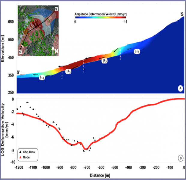
DORIS exploited the unique ESA ERS-1/2 and ENVISAT C-band Synthetic Aperture Radar (SAR) archives to provide unprecedented, very long time-series of ground deformations. DORIS has evaluated new SAR sensors, and constellation of sensors, including ALOS, COSMO-SkyMed and TerraSAR-X. The service exploited the significantly reduced revisiting time and the higher spatial resolution provided by the new X-band sensors. Through the massive processing of more that 2700 SAR scenes, DORIS has prepared a total of 42 deformation maps, deformation velocity maps, and associated time series for 13 test sites, delivering more than 30-million point-scatters on the ground, with an average density of 830 points per km2.
DORIS moved forward the combined application of satellite and ground-based differential SAR interferometry, coupled with geophysical probing and numerical modelling for an improved monitoring and forecasting of ground deformations.
Products
DORIS has published papers in international journals, including:
Calò, F., Ardizzone, F., Castaldo, R., Lollino, P., Tizzani, P., Guzzetti, F., Lanari, R., Angeli, M.-G., Pontoni, F. and Manunta, M. (2014) Enhanced landslide investigations through advanced DInSAR techniques: The Ivancich case study, Assisi, Italy, Remote Sensing Environ, 142, 69–82, doi:10.1016/j.rse.2013.11.003.
Del Ventisette, C., Ciampalini, A., Manunta, M., Calò, F., Paglia, L., Ardizzone, F., Mondini, A. C., Reichenbach, P., Mateos, R. M., Bianchini, S., García-Moreno, I., Füsi, B., Deák, Z., Rádi, K., Graniczny, M., Kowalski, Z., Piatkowska, A., Przylucka, M., Retzo, H., Strozzi, T., Colombo, D., Mora, O., Sánchez, F., Gerardo, H. G., Moretti, S., Casagli, N. and Guzzetti, F. (2013) Exploitation of Large Archives of ERS and ENVISAT C-Band SAR Data to Characterize Ground Deformations, Remote Sensing, 5(8), 3896–3917, doi:10.3390/rs5083896.
Guzzetti, F., Mondini, A. C., Cardinali, M., Fiorucci, F., Santangelo, M. and Chang, K.-T. (2012) Landslide inventory maps: New tools for an old problem, Earth-Sci Rev, 112(1-2), 42–66, doi:10.1016/j.earscirev.2012.02.001.
Mondini, A. C., Guzzetti, F., Reichenbach, P., Rossi, M., Cardinali, M. and Ardizzone, F. (2011) Semi-automatic recognition and mapping of rainfall induced shallow landslides using optical satellite images, Remote Sensing Environ, 115, 1743–1757, doi:10.1016/j.rse.2011.03.006.
Conclusions
DORIS has:
- Consolidated expertise in the use of EO data & technology for the detection, mapping, monitoring and forecasting of ground deformations in Europe.
- Strengthened the effective exploitation of satellite data and technology for the detection, mapping and monitoring of ground deformations, chiefly landslides and ground subsidence.
- Integrates satellite and ground-based data and technologies to improve the understanding and forecasting of ground deformations.
- Raised the awareness of landslide and subsidence phenomena, and of the possibility of using space data and technology to monitor the deformations, and to help managing the problems caused by the deformations.