
Radar remote sensing techniques for the detection and measurements of ground surface deformations
(DInSAR)
Background
Space-borne radar interferometry or DInSAR (Differential Interferometric Synthetic Aperture Radar) is one of the latest techniques used for the detection and measurement of ground surface deformations caused by natural and / or man-made events. The DInSAR technique has been successfully used in the measurement of seismic deformations and of the effects of subsidence, unstable slopes and inflation of magma in volcanoes. The growth of space missions dedicated to radar remote sensing and the consequent availability of a large number of images, has allowed the development of more sophisticated techniques, denominated A-DInSAR (Advanced Differential Interferometric Synthetic Aperture Radar), which allowed to overcome some limitations in the original approach and to achieve better results in terms of resolution and precision. The free of charge images acquired by the new generation of SENTINEL-1 satellites of the European Space Agency (ESA) represent a great stimulus for research and possible new applications.
Purpose
The main objective of the research project is to develop a surveillance and monitoring system in quasi-real time of the deformations induced by natural and / or anthropic processes, starting from the elaboration of the data acquired from SENTINEL-1A and SENTINEL-1B satellites. The project aims to develop algorithms that, as last instance, are able to generate time series that allow to characterize the state and the style of activity of the deformation process and therefore to define the risk.
Methods
The interferometric processing of the SENTINEL-1 data will be performed using the Gamma software, and other open-source programs. The data will be interpreted in the first instance by the PSTime code and will be validated on the sites of interest by means of geomorphological surveys and / or by direct comparison with the data acquired from traditional topographic monitoring networks (i.e. total stations, GNSS receivers, etc.).
Results
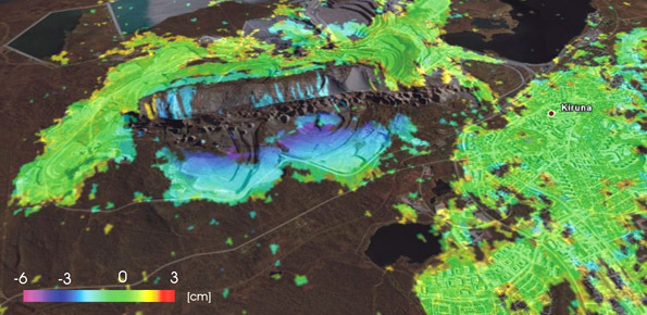
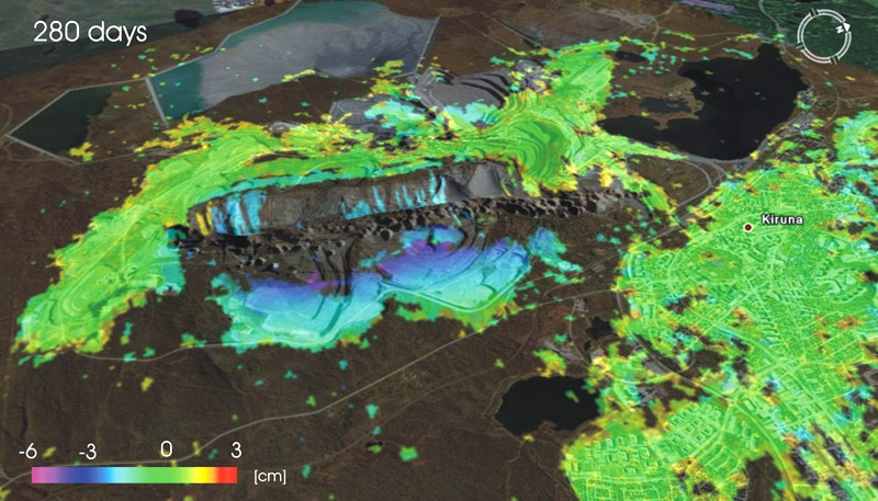
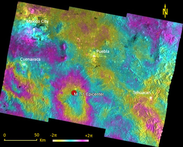
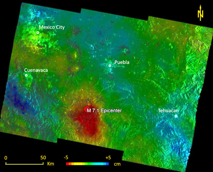
Through the interferometric processing of the data acquired by the SENTINEL-1 satellites it is possible to identify and measure crustal deformations produced by earthquakes, landslides, subsidence permafrost degradation in strongly limiting conditions. The results obtained show, in terms of precision, resolution and number of identified Persistent Scatterers, a marked improvement over those achieved by the data acquired from the ERS and ENVISAT satellites.
Products
FLORIS M., FONTANA A., FONTANEL G., MANTOVANI M., PASUTO A., RONCHI L., BOSSI G., RICCARDI P., TESSARI G. (2018). Monitoring of subsidence in the lowland area between the Piave and Livenza rivers using A-DInSAR techniques. 6° Congresso Nazionale AIGA 2018, Courmayeur (AO) 27-29/06/2018.
FIASCHI S., MANTOVANI M., FRIGERIO S., PASUTO A., FLORIS M. (2017). Testing the potential of Sentinel-1A TOPS interferometry for the detection and monitoring of landslides at local scale (Veneto Region, Italy). Environmental Earth Sciences, vol. 76(14), 492. doi: 10.1007/s12665-017-6827-y.
MANTOVANI M., PASUTO A., SOLDATI M., POPOVIC R., BERTHLING I. (2017). Assessing slope dynamics in a climate-sensitive high arctic region with Sentinel-1 dataset. Geophysical Research Abstracts Vol. 19, EGU2017-14876. EGU General Assembly 2017, Vienna (Austria) 23-28 April 2017.
ROCCHEGGIANI M., MANTOVANI M., PERISSIN D., PIACENTINI D., TAMBURINI A., TRINCANTI A., TRINCANTI E., MENICHETTI M. (2017). Dati Sentinel-1 per l’analisi dell’evoluzione e il monitoraggio dei fenomeni franosi in aree urbane. XII Convegno Nazionale GIT – Geoscienze e Tecnologie Informatiche della Società Geologica Italiana, Gavorrano (GR) 12-14/06/2017.
Conclusions
The accuracy of the SENTINEL-1 satellite orbits, the short revisiting period and the innovative imagine technique have allowed to obtain very promising results even in strongly limiting conditions. These conditions also favor a continuous control of the deformation processes and a quasi-real time monitoring.
 Internal contact person: matteo mantovani -