
Landslide risk and urban planning in small settlements in Daunia
Landslide risk assessment for the planning of small urban settlements within chain areas: the case of Daunia.
Background
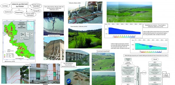
The Strategic Project PS_119 was aimed at developing a methodology for the landslide risk assessment, applicable at the regional scale and based on the most advanced knowledge in the fields of geology, geotechnics, structural engineering and urban planning. This assessment was based on a deterministic approach of the landslide processes and the risks related to them. The failure slope mechanisms, the structural damages due to landsliding and the associated risk are pursed through several risk analysis performed at the large scale. This methodology has been applied to urban territories Daunian Apennine. The project involved close collaboration with 5 companies, who co-finance the project.
Purpose
The aim of the PS_119 project was to define a methodology for the landslide risk assessment according to both a quantitative modelling of the landslide processes and the consequent structure damage and a multi-disciplinary approach to the same problem. The project was also aimed at evaluating how land planning could account for the risk assessment resulting from the proposed methodology.
Methods
- Collection of previous data regarding the landslide processes occurred in the study territories;
- Phenomenological analyses of landslides (field surveys, multi-temporal aerial photography interpretation, studies of historical documents and maps, boreholes and monitoring data, geotechnical results);
- Numerical analyses of landslides (limit equilibrium analyses, numerical modelling)
- Analyses of the structural damages (field surveys, reconstruction of the structural damages pattern, numerical analyses)
- Analyses of the element at risk
- Data implementation in a GIS platform.
Results
- Definition of the geo-hydro-mechanical setting of the study territories;
- Definition of the landslide mechanisms occurring within the reference territories, together with the causes and evolution of the landslide processes;
- Definition of the representative patterns of the structural damages, due to mass movements, in relation with the building typology;
- Schematisation of the proposed methodology for the landslide risk assessment.
Products
- Archive of all the landslide factors resulting for the reference territory (geology, geomorphology, geotechnics, building typology, structural damages patterns, stabilisation works);
- Data inventory for the reference territory;
- Guidelines for the numerical analyses of the landslide processes occurring within the reference territory;
- Landslide manual for the reference territory;
- Thematic maps and landslide susceptibility maps for the reference territory.
Conclusions
The project has demonstrated that the landslide risk assessment, based on a deterministic approach, should result from a multi-disciplinary analysis of the landslide processes, involving so different scientific expertises (geology, geotechnics, structural engineering, hydrogeology, computer science, town planning, topography, etc.). At the same time, the results achieved for the study area have shown that, even if complex, it is possible to identify a limited number of landslide mechanisms and geo-hydro-mechanical settings as recurrent and, therefore, representative of the slope failure processes. The simplification of the complexity, known as reductionism, resulting from a deep knowledge of the area, was necessary for reaching of the project goals.