
Turchia
The coloured circles represent the total number of activities (project, products and services, outreach, collaborations) that we have in the corresponding geographical zone
Map data: © OpenStreetMap contributors
Dove non dobbiamo aspettarci frane?
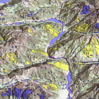 La suscettibilità da frana è la propensione di un territorio a franare.
Sono molti i metodi disponibili per determinare le aree suscettibili a franare, mentre sono pochi i tentativi di determinare le aree non suscettibili, ossia le aree dove non dobbiamo attenderci frane. Ciò è sorprendente, perché per la pianificazione territoriale è altrettanto (se non più) importante sapere dove non ci si aspettano frane che sapere dove le frane ...
La suscettibilità da frana è la propensione di un territorio a franare.
Sono molti i metodi disponibili per determinare le aree suscettibili a franare, mentre sono pochi i tentativi di determinare le aree non suscettibili, ossia le aree dove non dobbiamo attenderci frane. Ciò è sorprendente, perché per la pianificazione territoriale è altrettanto (se non più) importante sapere dove non ci si aspettano frane che sapere dove le frane ... STSE Water Cycle Multi-mission Observation Strategy for the Mediterranean
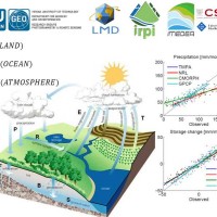 Monitoring the water cycle from satellite observations is one of the major goals of the EO community and closing the water budget has been a long-standing objective of international programs. After years of hard work, calibrating satellite data, improving inversion techniques, and facilitating the coherency of retrievals, it is admitted that the water cycle budget can now be ...
 Connettere la ricerca europea sulla connettività
 La connettività idrologica e del sedimento è emersa recentemente come importante framework concettuale per indagare il trasferimento dei flussi di acqua e sedimento nei bacini idrografici. La connettività può esser vista sia come forzante dei processi idrologici e delle azioni geomorfiche all'interno del bacino, sia come una proprietà del bacino stesso che è risultato di processi che agiscono a diverse ...
 Prevention, Information and Early Warning pre-operational services to support the management of risks
 PREVIEW is an integrated project by the European Commission 6th Framework Programme, led by the EURORISK Consortium, a multi-disciplinary European Team of committing Actors of the domain: Civil Protections and Environmental Bodies; Scientific communities and Service operators, at national and regional level, for Meteorology, Hydrology, Seismology, Volcanology and GIS services based on Space data; and Industry. The project was organized around a ...