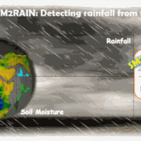
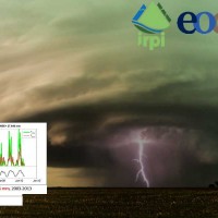
SM2RAIN è un innovativo sistema di stima della pioggia che si basa sul contenuto d’acqua nel suolo. SM2RAIN considera il suolo come un grande pluviometro naturale e, misurando le variazioni della quantità di acqua nel suolo, stima la pioggia caduta (approccio “bottom-up”). In termini tecnici, SM2RAIN fa riferimento all’inversione dell’equazione di bilancio idrologico del suolo che calcola la ripartizione delle precipitazioni in ...
L'acqua è al centro dello sviluppo economico e sociale; è fondamentale per la salute, coltivare il cibo, gestire l'ambiente e creare posti di lavoro. Poiché oltre la metà dell'approvvigionamento mondiale di acqua potabile viene estratta dai fiumi, direttamente o da serbatoi, è di primaria importanza comprendere la variabilità dell'acqua immagazzinata sopra e sotto le masse terrestri, cioè il deflusso totale. Le osservazioni in situ o i ...
L'IRPI è da molti anni impegnato nel monitoraggio di variabili idrologiche (umidità del suolo, pioggia, portata e velocità dei corsi d'acqua) che è risultato fondamentale per la rappresentazione del processo di formazione del deflusso e quindi per lo studio delle piene e delle ...
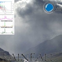
Rainfall-induced shallow landslides and floods are the most common and dangerous natural hazards, mainly due to their high temporal frequency, which causes fatalities and high economic damage worldwide. Climate changes will exacerbate this critical framework since an increase in extreme weather events is ...
Accurate rainfall estimates are of paramount importance as rainfall plays a key-role in many fields as, to cite a few, natural hazard assessment (floods and landslides), drought management, weather forecasting, agriculture and diseases prevention. State-of-the-art rainfall products obtained by satellites are often the only way for measuring rainfall in remote areas of the ...
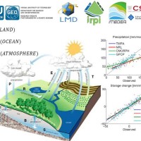
Monitoring the water cycle from satellite observations is one of the major goals of the EO community and closing the water budget has been a long-standing objective of international programs. After years of hard work, calibrating satellite data, improving inversion techniques, and facilitating the coherency of retrievals, it is admitted that the water cycle budget can now be ...
Quantitative information about precipitation is one vital input to meteorologists, hydrologic scientists, water resources managers, and environmental legislators. Yet, accurate measurement of precipitation over the relevant space and time scales remains a challenge. Soil moisture can be seen as the trace of the precipitation and, consequently, can be useful for providing a way to estimate rainfall accumulation or at least a new constrain to ...
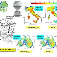
State-of-the-art satellite rainfall products are often the only way for measuring rainfall in remote areas of the world. However, these products may fail in properly reproducing the amount of precipitation reaching the ground, which is needed for hydrological applications. The integration of satellite soil moisture products is expected to significantly improve rainfall ...
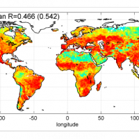
Recently, IRPI-CNR has developed an innovative approach for estimating rainfall from satellite soil moisture data, named SM2RAIN. The ESA funded project “Climate Change Initiative - Soil Moisture“ (CCI-SM) offers a valuable opportunity for testing SM2RAIN algorithm to a continuous, homogenous, long-term (>30 years) soil moisture time series. Indeed, SM2RAIN has the chance to be tested not only for rainfall estimation but also as a ...
The project aims at using Soil Moisture Active and Passive (SMAP) soil moisture (SM) products at different spatial resolution (3, 9, and 36 km) for hydrological applications in Europe (mainly in ...
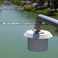
Il monitoraggio idrometeorologico è lo strumento operativo per la misura delle variabili atmosferiche, idrologiche e idrauliche che caratterizzano il ciclo idrologico e rappresenta il fondamento delle attività di ricerca dell’Istituto finalizzate alla previsione, prevenzione e mitigazione dei rischi naturali. Infatti, una corretta conoscenza dei processi alla base dei fenomeni naturali non può prescindere della misura diretta di grandezze ...
Il servizio si propone di valutare il potenziale di diversi prodotti satellitari (provenienti da sensori a micro-onde attive e passive, ottici, SAR, spettroradiometri) nella stima delle principali variabili idrologico-idrauliche quali pioggia, contenuto d’acqua del suolo, livello idrometrico, velocità di flusso e portata. Tale obiettivo viene raggiunto attraverso un’analisi di validazione globale che tiene conto di dati misurati in-situ o ...
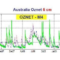
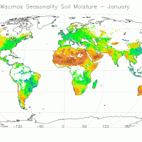
Il dataset di pioggia racchiude le stime pluviometriche ottenute tramite l’applicazione di un algoritmo di inversione a dati di contenuto d’acqua. L’algoritmo è stato applicato a dati provenienti da stazioni di monitoraggio in situ e a dati satellitari ottenuti tramite varie tipologie di ...
The H-SAF generates and archives high-quality data sets and products for operational hydrological applications starting from the acquisition and processing of data from Earth observation satellites in geostationary and polar orbits operated both by EUMETSAT and other satellite organization. The retrieval of products uses data from microwave and infrared instruments and aims at reaching the best possible accuracy compatible with satellite ...
The CCI Programme wants to contribute to the data bases collecting ECVs required by GCOS (Global Climate Observing System) and other international parties. In particular, the Soil Moisture CCI will analyse the needs of the climate research community in terms of soil moisture data, adapt soil moisture satellite measurements for their use by the climate research community and create a long-term consistent soil moisture time series, based on ...
