When soil behaviour is studied, whether landslide soils are concern, levee materials or foundations, the problem regarding how much and how reliable information about the soil properties we have available has to be addressed.
Understanding “what’s beneath” the visible surface is fundamental, yet complicated. Drillings are performed to analyse the stratigraphy of soils (the order and the thickness of the different soil levels) and ...
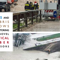
With more than 5 million people affected, more than 1000 killed, and with estimated total damages exceeding 4.5 billion Euros just in Europe and during the last decade, floods are among the most disruptive natural events threatening our Society. Due to increase in extreme weather events and rapid socio-economic developments in vulnerable locations, the risks connected to floods in general are growing rapidly, and the awareness of these risks ...
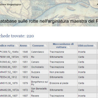
This is the web-based relational database on the main levee breaches of the Po River (Italy), which have occurred since the year 1800.
The database contains more than 200 fact sheets that show the information for each levee failure. For each fact sheet are attached documents and maps. The access is free of charge.
This database may provide a valid support in the design of defense interventions directed at the prevention and mitigation of ...
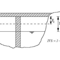
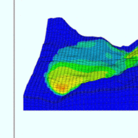
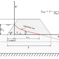
Assessment of bridge piers/abutments vulnerability to scour and overtopping hazard, assessment of levee vulnerability to seepage and overtopping hazard. The analysis is based on clearly identified criteria. Specifically, overtopping (IVS) and erosion (IVE) vulnerability indices are evaluated for each selected bridge, and the overtopping (IVsorm) and seepage vulnerability indices (IVsif) are calculated for the ...
National levees database, where the levees are identified by a code consisting in two parts: the first one identifies the river; the second one is a sequential number increasing from downstream to upstream. For each levee the location, the characteristics and topographic surveys are reported along with vulnerability to overtopping and piping, flood hazard maps and information about levee inspection and ...
The project activities were carried out in two phases:
"dynamic scenarios of flood risk" identification through hydrologic-hydraulic modeling addressed to Civil Protection activities (2009-2011);
operational implementation of developed dynamic scenarios of flood risk and results dissemination trough web-GIS technologies, also within the context of Floods Directive 2007/60 /EC (2012-203); flood forecasting models implementation; ...
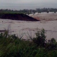
In the last decades Europe and Italy suffered many damaging floods, causing thousands of deaths, the displacement of millions of people and billions of euros in insured economic losses. Veneto Region has been also strongly stricken in 2010. The European Commission has identified the need for adaptation of risk management in several documents in order to reduce the likelihood and/or the impact of floods [1]. Starting from these remarks, the main ...
