Mappatura, Modellazione e Previsione Multiscala dei RIschi GEo-idroLogici
Develop new knowledge of geo-hydrological hazards to mitigate risk and to contribute to effective and sustainable land and urban planning (M3RIGEL)
Background
Italy has a tradition of scientific research and technological development on hazardous natural phenomena in general, and specifically on geo-hydrological hazards. Within the CNR, the “Progetti Finalizzati” Soil Conservation and Geodynamics (in the ’70s and ’80s), and GNDCI – the National Group for the Defence from Hydrogeological Disasters (in the ’80s and ’90s), have contributed to the advancement of knowledge on landslides, flooding, erosion and drought, for the protection and enhancement of water resources, and to design of strategies for risk mitigation.
M3RIGEL – Multiscale Mapping, Modeling and Forecasting Geo-Hydrological Risk executes scientific research and technological development on geo-hydrological hazards. The researchers involved in M3RIGEL have multidisciplinary expertise useful to investigate geo-hydrological processes and phenomena, the estimation of the related hazards, vulnerability and risk, and the assessment of the effects of climate change and land use on geo-hydrological hazards, at different spatial and temporal scales.
Purpose
The scope of the M3RIGEL project – Multiscale Mapping, Modeling and Forecasting Geo-Hydrological Risk is to integrate research and development activities conducted in different projects, and to develop new multi- and inter-disciplinary activities aimed at the development of new knowledge and a better understanding on geo-hydrological phenomena and processes, especially landslides, and on the risks posed by geo-hydrological events to the population and the environment.
M3RIGEL develops a common conceptual framework for the analysis of various natural hazards in Italy, in Europe and in the Mediterranean region. Given that risk depends on the interaction between phenomena (natural and human induced) and systems (essentially anthropogenic), the M3RIGEL objectives include:
- The investigation of potentially hazardous geo-hydrological phenomena and processes
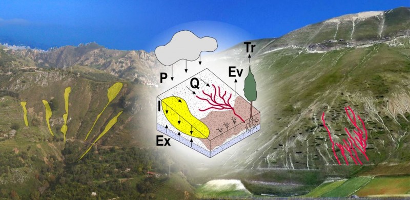
- The analysis of the relations between geological structure and landslides
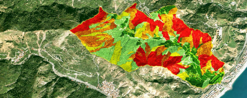
- The assessment and mapping of landslide susceptibility and hazard, at different spatial and temporal scales and in different physiographic and climatic environments
- The estimation of the vulnerability of various elements at risk, and the definition of risk levels for the population, private and public property, the economy and the environmental resources
- The investigation of the effects of climate and environmental changes on geo-hazards, chiefly landslides
Methods
The research and development activities carried out in the multi-disciplinary M3RIGEL project exploit a variety of tools, methods and strategies, including:
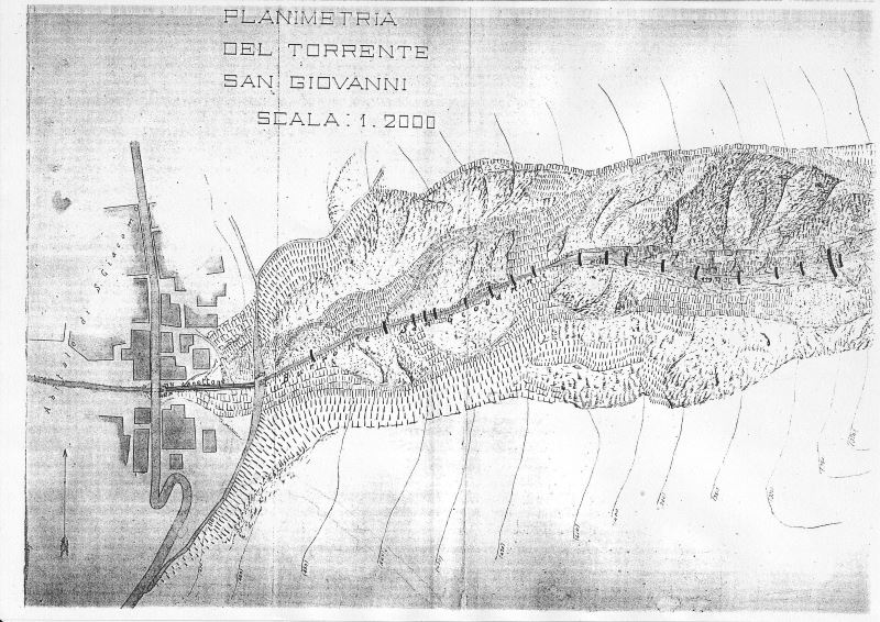
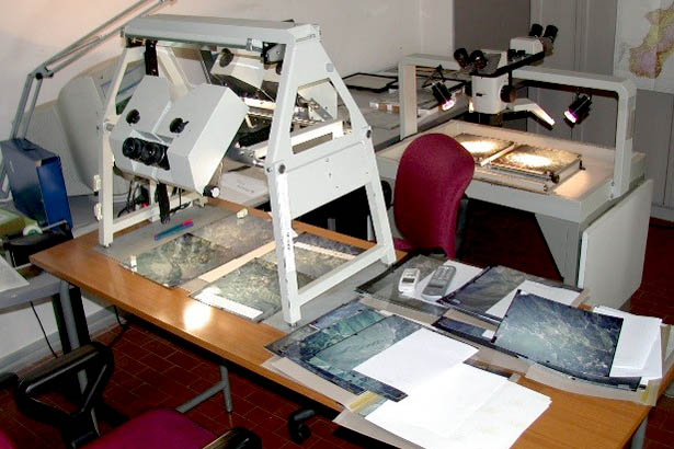
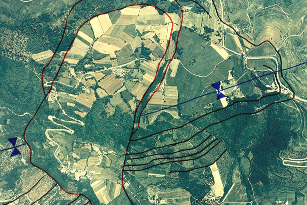
- The visual interpretation of stereoscopic aerial photographs for the production of geological and geo-morphological maps
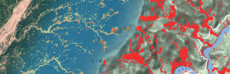
- The automatic and semi-automatic analysis of optical and SAR satellite images for the production of event landslide inventory maps
- Software and numerical models for geo-hydrological susceptibility, hazard and risk modeling
- Software systems for the collection, storage, management and processing of data and information on geo-historical hydrological events
- The development of specific procedures and software for the definition of rainfall events, for the estimation of the rainfall conditions that can result in landslides, and for the validation of landslide forecasting systems.
- The design and the development of multimedia strategies and tools for the dissemination of information on geo-hydrological hazards and risk.
M3RIGEL uses Open Source (GRASS GIS, QGIS, PostGIS, MapServer, GeoServer, GeoNetwork, OpenLayers, GeoEXT, R) and commercial (ARCGIS, SPSS, Adobe Illustrator and Photoshop) software for the management of databases and spatial information, the production of models and maps, for the development of web-based procedures, and for information dissemination.
Results
M3RIGEL intends to contribute to advancing the knowledge on geo-hydrological risks and to the design of strategies for the effective and sustainable mitigation of geo-hydrological risks. In detail, the expected results include:
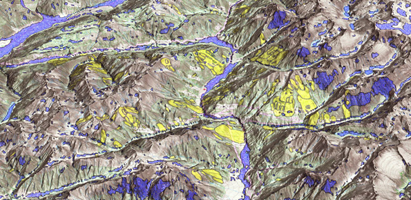
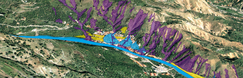
- Systems and tools for landslide detection and mapping in different climatic and morphological environments through the use of traditional (photo-interpretation) and innovative (automatic and semi-automatic procedures techniques based on the analysis of satellite images) techniques and procedures
- Analysis of local and regional relationships between landslides and the geological conditions in different geological and tectonic settings
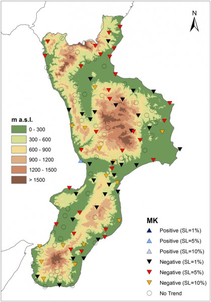
- Analysis of the impact of climate and environmental changes on landslides in Italy
- Models, zoning maps and susceptibility and landslide hazard assessments obtained through the use of multivariate statistical analysis and GIS technologies
- Catalogs of historical information on landslides and floods in Italy
- Models for the quantitative assessment of risk levels posed by landslides and flooding to the Italian population
- Criteria for the optimal use of maps, zonations and susceptibility models, hazard and risk assessments for regional and urban planning
- Dissemination of data and information on landslides and floods, and their consequences for the population of Italy
Products
Products expected from M3RIGEL include:
- Event, geomorphological and multi-temporal landslide inventory maps
- Innovative procedures for the production of landslide maps exploiting traditional techniques and innovative automatic and semi-automatic systems
- Characterization of local and regional relationships between the geological conditions and landslides in different geological and tectonic settings
- Assessments of the impact of climate and environmental change on landslides in Italy
- Models, maps and zonations of landslide susceptibility and hazard, at different scales and in different physiographic and climatic areas
- Catalogues of information on historical landslides and floods in Italy
- Evaluations of the landslide and flood risk levels to the population of Italy
- Guidelines for the proper use of susceptibility, hazard and risk maps and models, for regional and urban planning
- Web-based procedures for processing and effective publication of data and information on landslides and floods, and their consequences
Conclusions
In Italy, geo-hydrological events are widespread and endemic, and pose problems of scientific interest and of social and economic relevance. With M3RIGEL – Multiscale Mapping, Modeling and Forecasting Geo-Hydrological Risk we intend to contribute to advancing knowledge on geo-hydrological hazards and risk, and for the design of strategies for the effective and sustainable mitigation of geo-hydrological risks.