Investigations of the Ianò and Maierato landslides, Calabria, southern Italy
Geological, geotechnical, hydrological and hydraulic surveys in Ianò (Catanzaro Municipality) and in the Municipality of Maierato. (3862)
Background
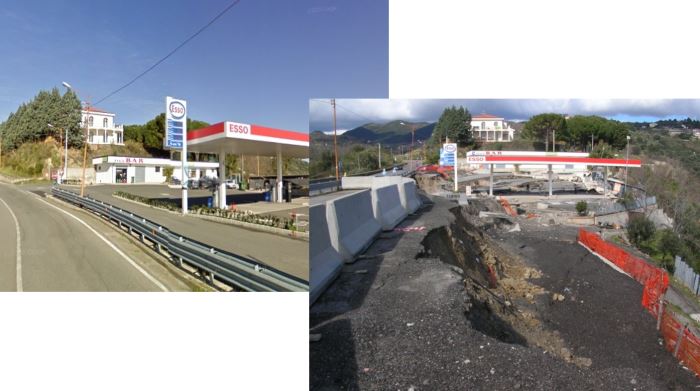
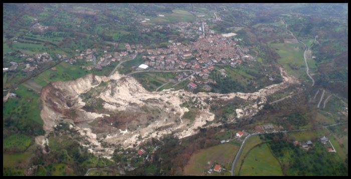
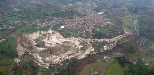
In the winter of 2009-2010, after the previous winter 2008-2009 when widespread hydrogeological instabilities had affected the whole of Calabria, the same area was still hardly hit by numerous and heavier instability phenomena, punctual and areal. In the context outlined it was ordered by the Italian Government to draft a “Plan excerpt for urgent action” which covered, in particular, the main city of the region, Catanzaro (Ianò district), and the town of Maierato, affected by a spectacular deep-seated and rapidly evolving landslide (link to Maierato video – http://www.bing.com/videos/search?q=youtube+frana+maierato&FORM=VIRE1#view=detail&mid=13D7320B5E26C7861D6913D7320B5E26C7861D69 ).
Purpose
The requested scientific activities concerned the interdisciplinary integration in emergency conditions of geological, geotechnical, hydrological and hydraulic surveys in the towns of Catanzaro (district Ianò) and Maierato. Moreover, appropriate monitoring plans were established, with the implementation of the networks installations, the proposal and the update of perimeter drafting relative to the residual risk.
Methods
For the required scientific activities, advanced disciplinary methods were used to treat the individual aspects (geological, geomorphological, hydrological, geotechnical, etc.), properly coordinated and integrated with an interdisciplinary work method, designed to enhance synergies. In particular, we have used: image analysis and site surveys for the recognition and mapping of landslide phenomena; innovative techniques, ad hoc developed, for the analysis of satellite images; techniques of statistical analysis of rainfall time series; indirect and direct geotechnical techniques for in situ investigation and laboratory experimentation; techniques for the geotechnical design of integrated networks for monitoring multiple landslide phenomena; geotechnical procedures for the analysis and modelling of the slope stability conditions; procedures for drafting perimeter of area with landslide risk.
Results
With reference to the emergency situation the following results were achieved: collection of information related to the required activities; geological and evolution models of the slopes for mass movements; information about the dates of possible phenomena of past occurred landslides; indications about the possible rainfall-landslide relations; in situ geotechnical investigations and core samples; geotechnical laboratory testing and physical-mechanical characteristics of the interested geomaterials; monitoring data of piezometric levels, displacements and related quantities; indications about the possible pore pressure regimen; information about the dimensional and kinematic characteristics of the landslide phenomena; geotechnical models of the landslide phenomena; geotechnical modeling for the scenarios definition relative to possible stability conditions of the interested slope; assessments of the possible residual risk conditions.
Products
With reference to what was specifically required for each development stages of the planned scientific activities, the following products were prepared/updated: analysis of the available information; schedules of studies and surveys; geolithological, geomorphological, geotechnical, hydrology, hydraulics and hydrogeology surveys; coordination of in situ investigations; historical investigation; model about the evolution of the landslide phenomena and periodic assessment of the residual risk level; supplementary surveys; analysis of the available information and monitoring network design; data acquisition system design; realization of the monitoring network; intervention model; rainfall-landslide model; data acquisition; maintenance of the monitoring system and network.
Conclusions
The project, due to the interdisciplinary synergies and the effective integration of technical-innovative procedures, has made available to the various Institutions more efficient elements of synthesis to better manage the emergency determined in the towns of Catanzaro (Ianò district) and Maierato for the landslide phenomena of winter 2009-2010. The work results and the products provide a qualified scientific support for drafting or reformulating the following actions: planning, programming, design and management of structural/not-structural measures to mitigate and reduce the landslides risk. In particular, monitoring networks and installations, properly managed in the medium to long term, can be instruments to measure the effectiveness of interventions and support to their maintenance-integration. The results also confirm the appropriateness and effectiveness of studies, surveys and monitoring conducted when there are events of hydrogeological instabilities, with particular reference to the typing of the involved phenomena.