
The 3DA software is a new procedure that allows retrieving in near-real-time 3D surface deformation models starting from data acquired via robotized total stations or others system that acquire the surface displacements. The measurements are first pre-processed and then implemented on 3D maps that include vector arrows representative of the intensities and of the real directions of motion in a given system of coordinates. The 3D surface ...
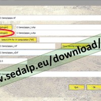
SedInConnect is a stand-alone application for the computation of the Sediment Connectivity Index (Cavalli et al., 2013, Crema et al., 2015).
The software has been developed in the frame of the SedAlp project, funded by the Alpine Space Programme (European Territorial Cooperation 2007-2013)
The output of the applied model is a topography-based index aiming at evaluating the potential connection between hillslopes and features acting as targets ...
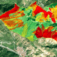
A landslide susceptibility map forecasts where landslides are expected to occur in the future based on terrain conditions, including local morphological, geological, and land use settings. Using different colors, a landslide susceptibility map shows forecasted levels of landslide susceptibility in a region. Using specific software, LSMMs can be prepared whene new landslides or new environmental (e.g., morphological, geological, land use) data ...
