
What’s underneath?
Inferring soil parameters through the integration of monitoring and numerical modelling

When soil behaviour is studied, whether landslide soils are concern, levee materials or foundations, the problem regarding how much and how reliable information about the soil properties we have available has to be addressed.
Understanding “what’s beneath” the visible surface is fundamental, yet complicated. Drillings are performed to analyse the stratigraphy of soils (the order and the thickness of the different soil levels) and laboratory tests are executed on different soil samples extracted at various depths. However, these data are scarce as compared to the extent of the investigated problem.
In fact, bore cores (the “pipes” of soils that are extracted by the drilling machine) are small with respect to the amount of soil that there is beneath a warehouse or inside a landslide (Fig.2 new). How should we switch from bore cores data to a reliable model that covers all the investigated area?
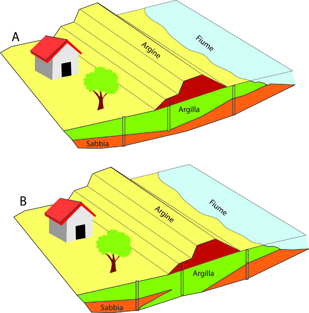
Fig. 2: Knowing the arrangement of different soil layers from few bore cores is difficult. In theory, both the A and B arrangements are congruent with the three bore cores.
(A) drilling machine to extract soil borecores; (B) soil samples extracted from borehole S3 in a landslide located in the Dolomites (North East Italy); (C) stratigraphic scheme of borehole S3 (around 50 m long), in the red rectangol is highlighted the section of the borecores photographed in B.
(A) drilling machine to extract soil borecores; (B) soil samples extracted from borehole S3 in a landslide located in the Dolomites (North East Italy); (C) stratigraphic scheme of borehole S3 (around 50 m long), in the red rectangol is highlighted the section of the borecores photographed in B.
(A) drilling machine to extract soil borecores; (B) soil samples extracted from borehole S3 in a landslide located in the Dolomites (North East Italy); (C) stratigraphic scheme of borehole S3 (around 50 m long), in the red rectangol is highlighted the section of the borecores photographed in B.
Monitoring is a common approach to understand “what’s underneath”. Through the installation of different types of sensors in a construction site or on a landslide, such as for measuring displacements or soil moisture, we can infer important information on the soil strength and permeability. This approach is called “observational method” and it has been an integral part of the practice of geotechnics (the discipline that studies soil mechanics) for little less than a century. The new methods that I develop to understand better “what’s beneath” are based on monitoring data from landslides and levees.
In this framework, the research focuses on the development of algorithms and numerical methods to extract more information from stratigraphic, laboratory and monitoring data. The methods rely on the generation of thousands of possible numerical configurations of the landslide or the levee to assess the variability of the different solutions due to the effect of soil layers arrangement.
It is in fact fundamental to quantify how big might be the error in which a researcher or designer might incur if the analysis starts from a pre-defined set of data (Fig.3). In some cases, it might result that the data available are sufficient, in other cases, the potential errors might be very significant and thus a secondary investigation campaign to gather more data is required. Other methods that I developed indicate whereat it is more advantageous to install new sensors or drill other boreholes in order to direct wisely the resources for new drillings.
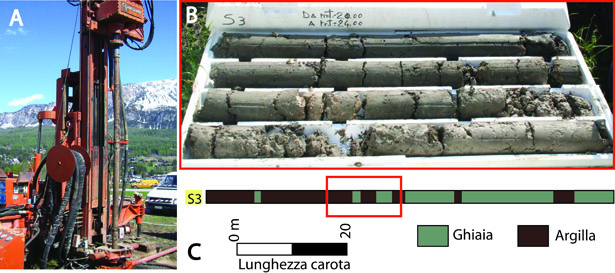
Fig. 3: (A) drilling machine to extract soil borecores; (B) soil samples extracted from borehole S3 in a landslide located in the Dolomites (North East Italy); (C) stratigraphic scheme of borehole S3 (around 50 m long), in the red rectangol is highlighted the section of the borecores photographed in B.
Results
The methods developed by myself for the analysis of the influence of soil arrangement and soil properties in numerical models were applied to problems regarding the stability of landslides and levees. The use of these methods allows the design of structural risk mitigation works based on methods that are more reliable. This will lead to a reduction of intervention costs and an increase of the overall safety. Besides the methods for the localizations for a further investigation campaign that will analyse the nature and dynamics of the soils in the investigated area will allow to optimize resources and to better plan a further monitoring campaign.
To know more
Bossi G, Borgatti L, Gottardi G, Marcato G. 2016. The Boolean Stochastic Generation method – BoSG: A tool for the analysis of the error associated with the simplification of the stratigraphy in geotechnical models. Engineering Geology 203, 99-106. DOI: 10.1016/j.enggeo.2015.08.003.
Bossi G, Bersan S, Cola S, Schenato L, De Polo F, Menegazzo C, Boaga J, Cassiani G, Donini F, Simonini P. 2018. Multidisciplinary Analysis and Modelling of a River Embankment Affected by Piping. Internal Erosion in Earthdams, Dikes and Levees , 234-244. DOI: 10.1007/978-3-319-99423-9_22.
 Contact person: giulia bossi -