
Automatic delineation of Slope Units
A software for Slope Unit delineation and a method for their optimization in arbitrarily large areas
Quantitative geomorphological and environmental analysis requires the adoption of mapping units, well-defined spatial domains as basic mapping units which provide local boundaries to aggregate environmental and morphometric variables and to perform calculations. Grid cells, typically aligned with a digital elevation model, are the standard mapping unit choice. A wiser choice is represented by slope units, irregular terrain partitions delimited by drainage and divide lines, bearing a stronger relation with the underlying topography, absent in grid cell-based analyses.
We developed a software for the automatic delineation of slope units, given a digital elevation model. Delineation is adaptive, in that slope units of different shape and, most importantly, different size, are delineated according to local terrain characteristics.
Moreover, we devised an optimisation procedure for the size of slope units, suitable for study areas of arbitrarily large size and with varying degrees of heterogeneity. Figure below shows an example of different slope unit delineations with different sizes (A, B, C). Different delineations are nested into each other (D, E). The figure also shows landlsides in the area, for illustrative purposes.
We suggest the use of the slope unit map for different terrain zonations, including landslide susceptibility modelling, hydrological and erosion modelling, geo-environmental, ecological, forestry, agriculture and land use/land cover studies requiring the identification of homogeneous terrain domains facing distinct directions.
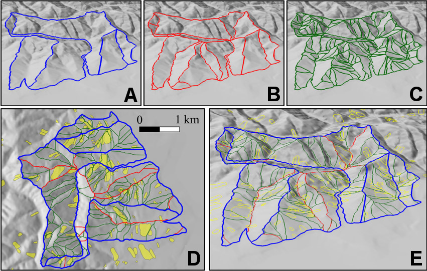
Example of different slope unit delineations with different sizes (A, B, C)
Results
We applied slope units delineation for many scientific papers studying different areas of the world and for different purposes, including landslide susceptibility zonation, aggregation of results of cell-based slope stability models, earthquake-induced landslide prediction, and optimization of landslide mapping from satellite images.
We recently applied the approach to the whole of Italy, resulting in a map containing about 330,000 slope unit polygons of different sizes and shapes, and with varying local granularity. The map is available for download on our website.
Granting institutions
- Project RFI-SERVICE
To know more
Software and maps available at the wesite of CNR IRPI’s Geomorphology group »
Citations:
Alvioli M., Guzzetti F., Marchesini I., (2020). Parameter-free delineation of slope units and terrain subdivision of Italy. Geomorphology 258, 107124. https://doi.org/10.1016/j.geomorph.2020.107124
Alvioli M., Marchesini I., Reichenbach P., Rossi M., Ardizzone F., Fiorucci F., Guzzetti F. (2016). Automatic delineation of geomorphological slope units with r.slopeunits v1.0 and their optimization for landslide susceptibility modeling. Geoscientific Model Development 9, 3975-3991. https://doi.org/10.5194/gmd-9-3975-2016
Other works that make use of slope units obtained with the software:
Jacobs L., Kervyn M., Reichenbach P., Rossi M., Marchesini I., Alvioli M., Dewitte O. (2020). Regional susceptibility assessments with heterogeneous landslide information: Slope unit- vs. pixel-based approach. Geomorphology 256, 107084. https://doi.org/10.1016/j.geomorph.2020.107084
Domènech G., Alvioli M., Corominas J. (2020). Preparing first-time slope failures hazard maps: from pixel-based to slope unit-based. Landslides 17, 249-265. https://doi.org/10.1007/s10346-019-01279-4
Tanyas H., van Westen C. J., Persello C., Alvioli M. (2019). Rapid prediction of the magnitude scale of landslide events triggered by an earthquake. Landslides 16, 661-676. https://doi.org/10.1007/s10346-019-01136-4
Tanyas H., Rossi M., Alvioli M., van Westen C. J., Marchesini I. (2019). A global slope unit-based method for the near real-time prediction of earthquake-induced landslides. Geomorphology 327, 126-146. https://doi.org/10.1016/j.geomorph.2018.10.022
Bornaetxea T., Rossi M., Marchesini I., Alvioli M. (2018). Effective surveyed area and its role in statistical landslide susceptibility assessments. Nat. Hazards Earth Syst. Sci. 18, 2455-2469. https://doi.org/10.5194/nhess-18-2455-2018
Alvioli M., Mondini A.C., Fiorucci F., Cardinali M., Marchesini I. (2018). Topography-driven satellite imagery analysis for landslide mapping. Geomatics, Natural Hazards and Risk, 9, 544-567. https://doi.org/10.1080/19475705.2018.1458050
Schloegel R, Marchesini I., Alvioli M., Reichenbach P., Rossi M., Malet J.-P. (2018). Optimizing landslide susceptibility zonation: Effects of DEM spatial resolution and slope unit delineation on logistic regression models. Geomorphology 301, 10-20. https://doi.org/10.1016/j.geomorph.2017.10.018
Alvioli M., Guzzetti F., Rossi M. (2014). Scaling properties of rainfall induced landslides predicted by a physically based model. Geomorphology 213, 38-47. https://doi.org/10.1016/j.geomorph.2013.12.039
 Contact person: massimiliano alvioli -