Progetto 2022PFNNRS_PE10_PRIN2022 – PNRR M4.C2.1.1 – Finanziato dall’Unione europea – Next Generation EU – CUP: B93C22002120001 On 27 February 2026,...
Observing and understanding the interactions between geo-hydrological and geochemical processes in the Central Apennines The event is dedicated to the...
CNR IRPI is attending the International Conference of Geomorphology, taking place from 2 to 6 February in Christchurch, New Zealand,...
In merito alla copertura mediatica relativa alla frana di Niscemi, nell’ambito della quale i ricercatori dell’IRPI hanno collaborato rilasciando interviste...
Mercoledì 21 gennaio 2026, presso l’Aula dei Gruppi Parlamentari della Camera dei Deputati, si è svolto il simposio intitolato “La...
As of 1 January 2026, Dr. Marco Cavalli will take on the role of Head of the Padua Branch of...
Il 16 dicembre è stato presentato presso la sede operativa del Dipartimento della Protezione Civile a Roma il documento tecnico...
Per celebrare l’Anno Internazionale per la Preservazione dei Ghiacciai e l’inizio della Decade di Azione per le Scienze Criosferiche promossi dalle...
CNR-IRPI researchers Mauro Rossi, Maria Teresa Brunetti and Ivan Marchesini are attending, as invited participants of the Geological Survey of...
Delegations from ???????? IRPI Consiglio Nazionale delle Ricerche and from ???????? Amrita Vishwa Vidyapeetham University met last November 11 in...
Il 23 ottobre 2025 ha preso ufficialmente avvio il progetto MEASURES (iMpatto dElle frAne SU REti infraStrutturali), finanziato dall’Agenzia Spaziale...
Il 6 novembre 2025 l’IRPI partecipa alla giornata “Montagne che cambiano: Natura e Parchi alla prova del clima” organizzata da...
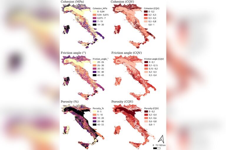
The dataset of geotechnical parameters for Italian lithotypes was created through a systematic review of international literature. Researchers compiled over...
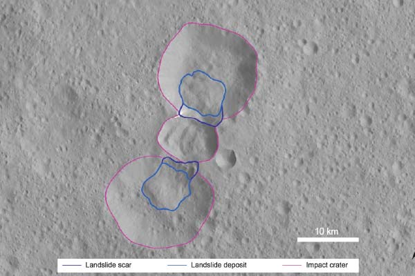
A collaborative study by CNR IRPI, Geoservizi Srl and the universities of Trento and Chieti-Pescara has revealed the mechanisms that...
The work introduces an innovative physically based framework for large-scale landslide susceptibility assessment, combining limit equilibrium analysis with spatialisation strategies...
A team of female and male researchers from the Institute for Research on Hydrogeological Protection (Cnr-Irpi) analyzed the effects of...
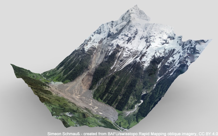
On 28 May 2025, at15:24 (CEST), the frontal part of the Birch Glacier in Valais (CH), estimated at around 3...
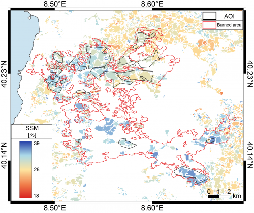
SM2RAIN is an innovative system for the estimation of the rainfall, based on measurements of the soil water content. SM2RAIN...
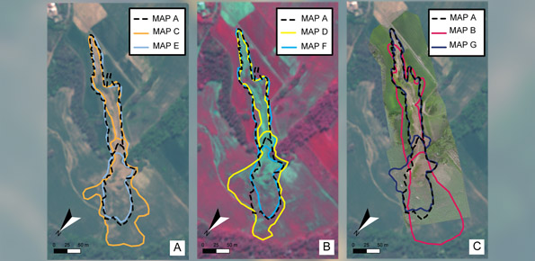
Landslides leave discernible signs on the land surface, most of which can be captured in remote sensing images. On the...
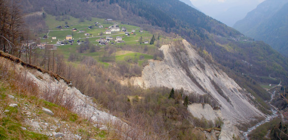
Worldwide, landslides pose a serious threat to the population, causing fatalities, widespread damages, and significant economic losses. Different phenomena influence...
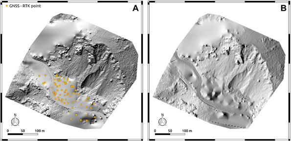
The use of remotely piloted aircraft systems (RPASs) in geosciences is often aimed at the acquisition of an image sequence...
The LiDAR sensor available to the institute has recently turned seven years since the first survey executed on November 2,...
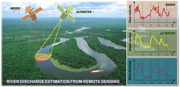
River discharge is defined as the amount of water flowing through a river over a specified period of time. Its...
The researches and the experimentations carried out, in the learning field, by the IRPI Institute during the last years, started...


 7809
7809
 153
153
 53
53
 166
7809
153
53
166
166
7809
153
53
166