69 contracts found
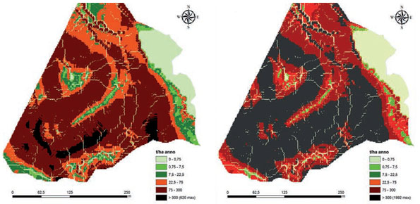
Pilot Project “Mitigation of the desertification processes in Calabria, in areas with a very high vulnerability”
From 20/09/2007 to 30/09/2009
Background Calabria is part of the 27% of the Italian territory deemed at desertification risk from the Plan of the National Area with Puglia, Sicilia and Sardegna. This project had…

Database of landslides in Calabria to be uploaded in the SyNaRMa computerized archives
From 01/12/2006 to 30/05/2007
Background The purpose of Convention contracted between the Research Institute for Geo-Hydrologic Protection (Rende) and the Department of Physics of the University of Calabria for partnership in the Program CE…

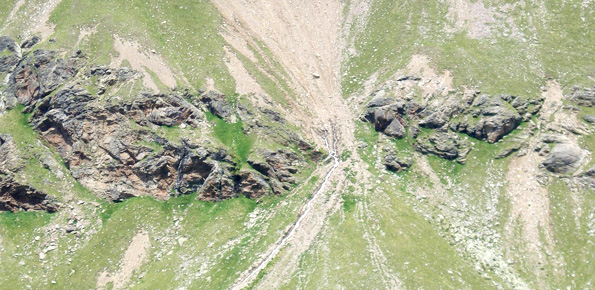
Methodologies for the analysis of alluvial fans
From 29/12/2014 to 29/12/2015
Background Some areas mapped in the Piani di Assetto Idrogeologico (Watershed Management Plan) of Piave, Brenta-Bacchiglione and Livenza Rivers require specific studies aimed at assigning a degree of hazard. Among…
Mappatura, Modellazione e Previsione Multiscala dei RIschi GEo-idroLogici
From 01/01/2016 to 31/12/2018
Background Italy has a tradition of scientific research and technological development on hazardous natural phenomena in general, and specifically on geo-hydrological hazards. Within the CNR, the “Progetti Finalizzati” Soil Conservation and Geodynamics…

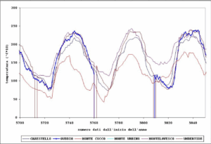
Siccità E Cambiamenti cLImatici
From 01/01/2009 to 01/01/2013
Background SECLI Project is aimed to assess the combined effects of processes related to natural and anthropogenic climate change on water resources, both surface and groundwater, in the Umbrian territory,…

Dynamic flooding scenarios
From 01/01/2009 to 01/01/2013
Background The project activities were carried out in two phases: “dynamic scenarios of flood risk” identification through hydrologic-hydraulic modeling addressed to Civil Protection activities (2009-2011); operational implementation of developed dynamic…

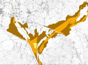
Flooding-prone areas delineation
From 01/01/2009 to 01/01/2013
Background The project activities were carried out in two phases: delineation of flooding-prone areas for many river reaches selected in the secondary hydrographic network of Tiber River basin (2009-2011); analysis…
Analysis, control and hydro-meteorological data processing – Rating curve estimate
From 01/01/2002 to 01/01/2015
Background The activities of the project concerns the analysis and processing of hydro-meteorological data collected by the monitoring network of the Umbria Region for the period 1994-2014. In particular, the…
Flooding-prone areas delineation for hydraulic risk assessment for river reaches of the secondary hydrographic network in Tiber river basin
From 01/01/2002 to 01/01/2009
Background The activities of the project concern the delineation of hazard maps for return periods of 50, 100, 200 and 500 years for many reaches of interest identified in the…

Integration of hydrometric measurements for river discharge monitoring and channel roughness coefficients assessment
From 01/01/2008 to 01/01/2009
Background River discharge monitoring is fundamental for the study of the hydraulic regime of river flow and for the validation and calibration of rainfall-runoff models. The assessment of channel roughness…

Hydrological and hydraulic studies to assess dam safety
From 01/01/2006 to 31/12/2009
Background The artificial reservoirs are fundamental for water resources management, by regulating releases to meet the different users request (industrial, irrigation, hydropower, etc.), and for downstream territories floods defence through…

Hydrological study of the Paglia river basin
From 01/01/2010 to 31/12/2012
Background The Tiber River Basin Authority (ABT) and the Umbria Region (Service Water Resources and Hydraulic Risk), considering the verified underestimation of the flood-prone areas in the Paglia River basin…

Modelling for real-time flood forecasting
From 01/09/2008 to 31/07/2010
Background The project activities concern: development and implementation of: 1) a semi-distributed continuous hydrological model (MISDc) for real-time soil moisture estimate and river discharge prediction in the Upper-Middle Tiber River…
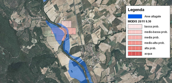
Upper-middle Tiber river basin: the flood event of 25-28 november 2005
From 01/01/2007 to 31/12/2007
Background On 25-27 November 2005, the territory of central Italy was affected by heavy rainfall that hit the Tiber River basin and, mainly, the province of Perugia. The meteoric event…
Civil Protection Competence Centre on Geo-Hydrological Risk
From 01/01/2015 to 31/12/2018
Background In Italy landslides and floods are frequent, widespread and dangerous phenomena, that cause fatalities and serious economic damage. In our country, landslides and floods pose major problems of scientific interest and…