Large-scale observation of reduced soil permeability in areas affected by extreme wildfires
Focus
Study of soil moisture using historical data series from the Sentinel-1 and Sentinel-2 satellites
Internal contact person: Giuseppe Esposito
Email: giuseppe.esposito@cnr.it

A team of female and male researchers from the Institute for Research on Hydrogeological Protection (Cnr-Irpi) analyzed the effects of an extreme wildfire on soils and low vegetation using multitemporal satellite data. The study, published in the journal Science of Remote Sensing (Esposito et al., 2025), focused on areas of Sardinia affected in 2021 by the Montiferru wildfire, which burned more than 122 km² and ranked among the most significant wildfires to occur in Italy.
The team used satellite data acquired by the ESA Sentinel-1 and Sentinel-2 constellations over a broad time window spanning the fire event, from 2017 to 2024. In particular, radar backscattering data in the VH polarization were compared with the NDVI and NDWI spectral indices derived from optical multispectral data, for analyses of herbaceous and shrub vegetation. The time series of VV-polarized backscattering data was compared with precipitation measurements and with soil water content estimated in the top 5 cm of soil at the agricultural field (plot) scale, provided by the Theia program.
The results showed that, following the first rainfall events after the wildfire, soil water content in the monitored areas exhibited anomalous behaviour within the analysed time series. Specifically, compared to the pre-fire period, even smaller rainfall amounts led to a larger, more rapid increase in soil water content. In other words, the soil moisture peaks observed during rainfall events between October and December 2021 were higher than those associated with much heavier pre-fire rainfall.
This anomaly was also observed when compared with nearby unburned areas, which were consequently drier than the burned ones. This behavior, which closely mirrors the trend observed in VV backscattering, can be explained by a strong reduction in soil permeability following the wildfire, thus promoting greater water accumulation limited to the upper, non-hydrophobic soil horizons.
The high availability of surface water may underlie the rapid recovery of herbaceous and shrub vegetation to pre-fire levels, clearly visible in the trends of the NDVI and NDWI indices as well as in VH backscattering, already 10 months after the wildfire. This study therefore reports, for the first time, evidence that had previously been observed only at point scale and discontinuously over time.
Such detailed information is fundamental for understanding the triggering conditions of post-fire geo-hydrological phenomena—such as landslides, soil erosion, and debris flows—and for implementing appropriate prevention measures. Indeed, phenomena of this kind actually occurred in the Montiferru area during the analyzed period, providing insights for further investigation.
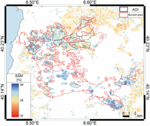
Map of soil water content (0–5 cm) on 27 December 2021, showing that within the area affected by the wildfire (red polygon) values are likely higher than those in surrounding unburned areas.
The graphs present the historical time series (2017–2025) of radar signals acquired by the Sentinel-1 satellite over the area of Sardinia affected by the extensive July 2021 wildfire. The analysis focuses on two polarisations:
• VH (Vegetation): measures volume scattering, which is closely related to vegetation structure.
• VV (Soil Moisture): is sensitive to surface roughness and soil water content.
Key results:
The most evident feature is the abrupt drop in the VH-polarised signal in the second half of 2021. This represents the unmistakable signature of the wildfire, demonstrating the drastic loss of biomass and vegetation structure destroyed by the flames. Variations in the VV channel reflect post-fire changes in soil moisture and surface roughness, due to direct soil exposure and alteration of the local hydrological cycle
Further details
For information: Giuseppe Esposito, Cnr-Irpi —
<a href=”mailto:giuseppe.esposito@cnr.it” target=”_blank” rel=”noreferrer noopener”>giuseppe.esposito@cnr.it</a>
For further details, please refer to the open-access article published in the journal Science of Remote Sensing, available at the following link:
<a href=”https://doi.org/10.1016/j.srs.2025.100339″ target=”_blank” rel=”noreferrer noopener”>https://doi.org/10.1016/j.srs.2025.100339</a>.
Esposito, G., Melillo, M., Notti, D., Brunetti, M. T., Peruccacci, S., Pisano, L., … & Cavalli, R. M. (2025). Response of the Sentinel-1 radar backscattering to an extreme wildfire event: surface soil moisture and vegetation cover implications. Science of Remote Sensing, 100339.
<a href=”https://doi.org/10.1016/j.srs.2025.100339″ target=”_blank” rel=”noreferrer noopener”>https://doi.org/10.1016/j.srs.2025.100339</a>
Zenodo dataset containing the study areas and Google Earth Engine scripts for extracting data from the Sentinel-1 sensor:
<a href=”https://zenodo.org/records/17491789″ target=”_blank” rel=”noreferrer noopener”>https://zenodo.org/records/17491789</a>