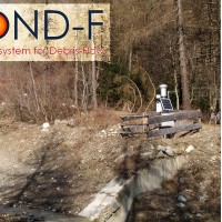
ALMOND-F is an innovative unit for the microseismic detection of debris flows using a network of geophones.
The microseismic detection of debris flows is more complex than other types of monitoring. Use of the geophones requires: (1) the selection of the level of amplification of the signal, which depends on the distance from the stream; (2) the selection of the sampling frequency of the seismic signal, which must be sufficiently high; (3) ...
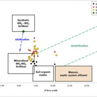
The company "Progetto Gestione Bacino Bari Cinque srl" has entrusted at the Research Institute for Geo-Hydrological Protection of the CNR the “Hydrogeological study for the risk analysis of the site where the plant of the treatment and disposal of solid urban waste of the same company is located in Contrada Martucci, municipality of Conversano ...
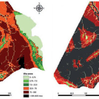
Calabria is part of the 27% of the Italian territory deemed at desertification risk from the Plan of the National Area with Puglia, Sicilia and Sardegna. This project had a realization in an area called Valle dell’Esaro, close to Crotone, that is an area with high desertification risk. In fact, this area for its soil, climate, morphology characteristics and for the agricultural procedures represents the best site to test a model of good ...

The 3DA software is a new procedure that allows retrieving in near-real-time 3D surface deformation models starting from data acquired via robotized total stations or others system that acquire the surface displacements. The measurements are first pre-processed and then implemented on 3D maps that include vector arrows representative of the intensities and of the real directions of motion in a given system of coordinates. The 3D surface ...
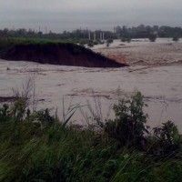
In the last decades Europe and Italy suffered many damaging floods, causing thousands of deaths, the displacement of millions of people and billions of euros in insured economic losses. Veneto Region has been also strongly stricken in 2010. The European Commission has identified the need for adaptation of risk management in several documents in order to reduce the likelihood and/or the impact of floods [1]. Starting from these remarks, the main ...

One of the main challenges in the field of engineering geology is the comprehension of the triggering mechanisms of landslides and the forecast of possible evolutionary scenarios in order to assess the correct mitigation measures. Landslides can be initiated by a variety of triggers: from earthquakes to meteorological events, including intense or prolonged rainfall, rapid snow melting, and variations of the surface temperature conditions. ...
