Increasing Resilience through Earth Observation
(INCREO)
Background
To significantly contribute to the operational capacities in the context of Global Monitoring for Environment and Security (GMES)/ Copernicus by developing customised mapping and geo-information products addressing risk, vulnerability and assets ready for deployment in the prevention and preparedness phases – complementary to the GMES/Copernicus Emergency Management Service. Solutions to be provided are based for the most part on Earth observation data and are tailored to user needs from the disaster management and civil protection domains.
Purpose
The objective of IncREO is to provide actors responsible for civil protection and disaster management with EO-based solutions contributing to an improved preparedness and mitigation planning for areas highly vulnerable to natural disasters and already noticeable climate change trends. As a multi-risk designed project any type of natural disaster is addressed. However, selected use cases and the transfer of solutions to a specifically multi-risk prone area are covered as well.
Methods
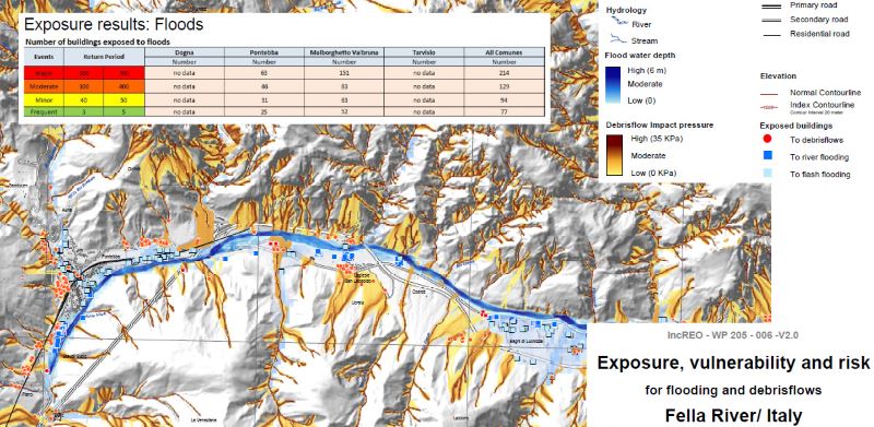
The emphasis in IncREO’s R&D activities is placed on assets mapping (i.e. geo-locating monetary values per area unit) and risk and vulnerability mapping for selected use cases (single and multirisk scenarios) across Europe. Assets maps are often used to create an inventory of the resources, items and utilities in a particular location – a fundamental aspect of preparing for damages caused by natural disasters. A three-tiered assets mapping approach is enable to accurately evaluate, estimate and compare various threats presented by extreme events at the national, regional and local scales in Europe. The basic European assets map (BEAM) is just one component of the three-tiered mapping product (national level) – this structure also includes high resolution assets mapping (HiRAM), which looks at the level of detail required by the end user on the regional level, and assets map plus (AM+), which optimises additional datasets at the local level. Some test sites have been selected to test the methodology and the products: Buzau County (Romania), Alpago Area and Fella River Basin (Italy), Shkodra (Albania), Bulgarian coast of the Black Sea and Köröszug, (Hungary).
Results
For the selected test sites several different type of maps have been produced and validated with local end users and stakeholders. In particular asset maps, landslide inventory maps, susceptibility maps, exposure maps, damage maps etc. Training courses addressed to local end users have been carried out in order to illustrate and test the Project results as well as the QGis software which has been selected as open source platform to implement the products. All the produced maps have been delivered to local authorities, civil protection institutions and emergency managers.
Products
The types of provided products are mainly “assets maps” and “hazard / risk and vulnerability maps”. Whereas “crisis phase” products such as damage extent / assessment maps and emergency support maps are already based on consolidated user requirements with corresponding product specifications available, there is still a certain R&D need in this regard concerning the aforementioned “non-crisis phase” products. The geo-information content of the final products usually corresponds to a multiple set including value-adding of EO data and various geo-formation layers, among them for example optical and / or radar satellite data, information about topography, population density and critical infrastructure.