
Landslide susceptibility models and maps
We ascertain landslide susceptibility, which is the likelihood of landslide occurrence in an area, given the local morphological, geological, land use and land cover, and environmental and climatic settings.
Landslide susceptibility is the likelihood of a landslide occurring in an area, given the local terrain conditions. It is the degree to which an area can be affected by future landslides i.e., an estimate of “where” landslides are more likely to occur.
Landslide susceptibility does not consider the temporal occurrence or the magnitude of the expected landslides. In mathematical language, landslide susceptibility can be expressed as the probability of spatial (geographical) occurrence of landslides, given a set of geo-environmental conditions.
Landslide zonation classifies the territory based on the likelihood of a landslide occurring. For landslide susceptibility zonation we exploit different methods and tools, that can be grouped into the following categories:
- Direct methods (geomorphological mapping) that rely on the ability of the investigator to estimate actual and potential landslides. They are subjective, and the results are often not reproducible.
- Heuristic methods, based on the a priori knowledge of all the causes and instability factors that may result in landslides. The methods is qualitative, and depends on how well and how much the investigator understands the geomorphological processes acting upon the terrain.
- Statistical approaches are based on the statistical analysis of the functional relationships between the instability factors and the past and present distribution of landslides. A statistical model is built on the assumption that the factors which caused landslides in a region are the same that will generate landslides in the future. The techniques and methods used are manifold, and have proved particularly suitable for producing models and susceptibility zoning for large and very large areas.
- Process-based models rely upon the application of simple physical models to explain the geographical distribution of landslides. Process-based approaches have traditionally been used to produce models and zoning of susceptibility for areas of limited extent, but are also applied to large areas.
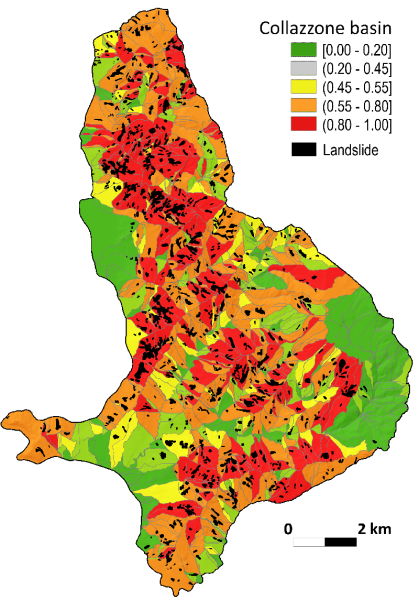
For the definition of the landslide susceptibility, and the production of susceptibility maps, we select an appropriate terrain mapping unit, which is a subdivision of the terrain suitable for the definition of landslide susceptibility. The most common mapping units are:
- Terrain units, which are based on the interrelations between materials, forms and processes that result in boundaries which frequently reflect geomorphological and geological differences.
- Grid-cells, that subdivide the territory into regular squares of pre-defined size which become the mapping unit of reference.
- Unique-condition units, which imply the classification of each slope-instability factor into a few significant classes which are stored into a single map, or layer. By sequentially overlying all the layers, homogeneous domains (i.e., unique conditions) are singled out whose number, size and nature depend on the criteria used in classifying the input factors.
- Slope-units, which are automatically derived from high-quality Digital Terrain Models (DTMs), partition the territory into hydrological regions between drainage and divide lines.
- Administrative units, which are administrative boundaries such as census zones, municipalities, provinces, or regions.
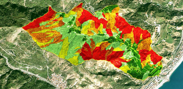
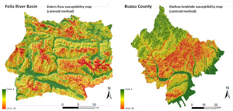
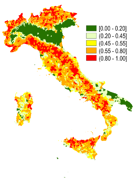
Landslide susceptibility maps are mandatory for landslide hazard and risk assessments and zoning, and can prove useful for planning and land management. Landslide susceptibility maps can also be used in landslide early warning systems.
Granting institutions
Projects funded by local and regional administrations, by the Italian National Department for Civil Protection, and by the European Commission.
To know more
Link to the website of the Geomorphology group »
Guzzetti F, Carrara A, Cardinali M, Reichenbach P. 1999. Landslide hazard evaluation: a review of current techniques and their application in a multi-scale study, Central Italy. Geomorphology, 31, 181-216. DOI: 10.1016/S0169-555X(99)00078-1.
Guzzetti F, Reichenbach P, Cardinali M, Galli M. and Ardizzone F. 2005. Probabilistic landslide hazard assessment at the basin scale. Geomorphology, 72, 272-299. DOI:10.1016/j.geomorph.2005.06.002.
Rossi M, Guzzetti F, Reichenbach P, Mondini A, Peruccacci S. 2010. Optimal landslide susceptibility zonation based on multiple forecasts. Geomorphology, 114, 129-142. DOI: 10.1016/j.geomorph.2009.06.020.

 Contact person: paola reichenbach -